Part 3a of a
four-and-a-half part series creating a map of the Chesapeake area and
surrounding environs circa the year 1600.
Click for: Part 1, Part 2, Part 3b, Part 4.

§
1.
Historical background
On eighteenth-century French maps
of North America you can sometimes find an interesting label under Carolina:

Carolina,
named in honor of King Charles IX, by the French who discovered and took
possession of it in 15.... / until the year 1660. This is in reference to the French Huguenot
colony of the 1560s, which consisted of Charlesfort in southern Georgia and
later Fort Caroline in northern Florida.
The French colony was destroyed by the Spanish in 1565, and while both
locations were indeed named after King Charles the Ninth of France, the idea
that he remained the namesake of English Carolina was as the kids say "cope". Because the area labeled on the maps clearly is English Carolina which, after all, is
named for King Charles II of England.
Furthermore, the French never even called that area "Carolina"
before the English started doing it (cf Salley 1926). They usually called it Florida, as on this
map of La Floride Françoise:
 |
| Map of Pierre du Val, 1665. |
I bring this up because actually,
funnily enough, the Carolinas are still kind
of named after more than one King Charles.
If I could alter history but was
only allowed to make minor, cosmetic changes, I would see to it that South
Carolina is called "Carolina", Virginia is called
"Jacobia", and North Carolina is called "Virginia"—each
named for the monarch under whom English colonization began. That would be cleaner, but alas in our actual
timeline things are slightly messy.
North Carolina was originally named
"Virginia" when Sir Walter Ralegh's men tried planting the first
permanent English settlement on Roanoke
Island. This as you know didn't
take. There were actually two Roanoke
colonies: the first lasted from 1585-6 but was then evacuated by the legendary
English sea captain Sir Francis Drake. A
second group of colonists was planted there in 1587 but was gone by 1590, their
ultimate fate unknown: they are remembered in history and legend as "The
Lost Colony" [see note A at bottom].
In 1607 when the English returned
to settle the Chesapeake Bay, they were still within the general region they
considered "Virginia" so they inherited the name... though by now
"the Virgin Queen" Elizabeth was dead, and the capital of their new
Virginia was named James Town after King James (he of the Bible). For some time thereafter the present North
Carolina—which the English still considered theirs though only the occasional
lone adventurer existed to preserve their squatter's-rights—was sometimes
called "Old Virginia" or "South Virginia". One map from 1650 gives it the nickname
"Rawliana":
.jpg) |
| Map of John Farrer, 1650. |
Meanwhile, in 1629 a charter for
a new colony was granted by King Charles, intended to be located between
English Virginia and Spanish Florida.
However, nothing became of this planned colony as things quickly got too
hot at home—with the beheading of Charles, the Civil War, Oliver Cromwell, and
all that—and no one was in the mood for colonization. In 1663, after things had settled down a bit,
a new grant was issued by the restored Stuart monarch Charles II. It was essentially the same as the old grant
but with a slightly revised name: the original colony was to have been named
"Carolana", but the younger Charles—perhaps to make it more
"his"—named the new colony "Carolina". Both charters defined the colony as all land
lying from 31°N to 36°N between the Atlantic and Pacific oceans... which not
only arrogated the territories of several dozen Indian tribes but by
implication claimed Spanish New Mexico as well.
 |
| Map from Walbert, "A little kingdom in Carolina". |
Thus Carolina was named after two
kings named Charles—only neither of them was French.
* *
*
The fruit of the Carolina grant
was the city of Charleston (or "Charles Town") founded in 1670 by a
group of English planters from Barbados.
This wasn't their first attempt: an earlier "Charles Town" had
been built at Cape Fear in 1664 but was abandoned in 1667. They in turn had been preceded by some
Puritans from New England who tried settling Cape Fear in 1663. But the second Charles Town became the real
nucleus and capital, and thenceforth the "history of Carolina" was
for all intents and purposes the history of South Carolina.

North Carolina didn't really
belong, and it should have gone on being called "South Virginia" as
it had before. If you look at the area
of English settlement in America as giant amoebae, then North Carolina first
appears as a pseudopod extending south from Virginia. People had been moving in there since around
1655 and settling along Chowan River and north of Albemarle Sound: the district
later known as the County of Albemarle. These settlers apparently called the region
"Roanoke" but officially they were Virginians. They were Virginians still when the 1663
charter came, as its original terms defined the border further south than it is
today. Only in 1665, when the border was
officially changed to its present latitude, did they become—on paper—Carolinians
(cf
Salley 1926, Butler 1971, McIlvenna 2009).
In short: North Carolina was
settled by the English in 1585-7 (unsuccessfully). It was later resettled (successfully) from 1655
onward. The seven decades in between (let's
call it the intercolonial period) are
mostly dark in the historical record, and reconstructing the Native American political
landscape circa 1600 A.D. requires some interpolation of the evidence.
* *
*
§ 2. Primary sources
It's not my interest here to retell
the whole saga of Sir Walter Ralegh and the Roanoke venture—if you need a
refresher then Lemmin0's video on Youtube is pretty good about it.
We obviously have no writings
from the Second or "Lost" Colony (except for "C R O A T O A
N"), but we do have some from the First Colony (1585-6). Alas they too are less extensive than we'd
hope. The colony's most interesting
members were John White and Thomas Harriot—they were the two I mentioned in
Part 1 who spent time among the Chesepioc.
White was an artist whose paintings are still our main visual reference
for Virginia-Carolina Algonquian lifestyles—he also made paintings of Timucuas
from Florida and Inuits from Greenland. Thomas
Harriot was a scientist and polymath who among other things is known for his
contributions to the sphere-packing problem in mathematics. Both of these men produced works which are
now lost, but it's Harriot's writings in particular that I miss the most as
they allegedly included a dictionary of the Secotan language [note B]. He had learned to speak this language (to
some extent at least) while he was still in England, by conversing with two
Indian captives taken during a scouting voyage in 1584.
 |
| Comparison of some Algonquian languages around Chesapeake Bay. |
These two Indians returned home
in 1585 on the same flotilla that brought the first colonists. Despite the fact that they had essentially
been kidnapped, one of them—a fellow by the name of Manteo—became something of
an anglophile, even opting to visit England for a second time in 1586 [note C]. According to some he was even made a baron of
the English Empire and invested with fiefdoms in America: "Lord of Roanoke
and Dasamonquepeuc". I've heard
contradictory reports whether this is true or not—if it was it can't have much
pleased Chief Wingina, who was the actual
lord of Roanoke and Dasamonquepeuc, as well as several other places.
Thomas Harriot's papers were
destroyed in the Great Fire of London.
Many of White's sketches were tossed into the sea during the evacuation
of the first Roanoke colony in 1586.
Fire and water, blasted things.
But I shouldn't make it sound like all
of their materials were lost to history—they were not. Most valuable here for my purposes are two
maps made by John White: one of the Carolina sounds region:

...and another of the general
southeast:

(Incidentally, I only reference
the first map, so if I say "White's map" that's the one I mean.)
Not 100% sure when these maps
were made—I've seen them cited as from either 1585 or 1586. Nor do I know whether they were made while
White was still in America, but if they were then that might account for the
presence of certain additions and corrections on the later Theodor de Bry map of
1590. De Bry was the man enlisted to
convert White's drawings into engravings that could be printed in the published
account of the Roanoke colony. Unlike
White, De Bry was not an eyewitness to the colony, and his map is much less
geographically accurate: consequently it's sometimes seen as less
reliable. Others however think that De
Bry may have based it on an otherwise-unattested map of White's, or that he
made it in consultation with White or another colonist.

The protruding horn of the Outer
Banks that you see on these and other early maps wasn't a mistake—that's a real
feature that used to exist, called Cape Kenrick. It was destroyed by a hurricane in the early
18th century, leaving the Outer Banks as they are now. It's not something I can reproduce on my own
maps.
As for textual sources: the
surviving works of Harriot and White are useful to anthropologists for
reconstructing the life and culture of the Carolina Algonquians. But when it comes to the geography and
politics—what I need to make a map—they're of less use, and instead we have to
rely on the writings of two other men: ship captain Arthur Barlowe, and Ralph
Lane, commander of the first Roanoke colony.
It was Lane whose violent personality led to the First Colony's failure—in
particular, his ordering the death of chief Wingina. However, "[in] spite of the development
of unfriendly relations between the natives and colonists under Lane's
governorship, Lane's account shows him to have been an individual of
ethnological discernment," according to Maurice Mook (1944:184).
As scant as the records are from
the Roanoke era (1584-90), they're even scantier for the Albemarle era
(1655+). People at the time just didn't seem
to write much about the Indians—or about the interior in general—and therefore
neithor do modern authors. Quoth the
adventurer John Lawson:
"'Tis a
great Misfortune, that moſt of our Travellers, who go to this vaſt Continent in
America, are Perſons of the meaner
Sort, and generally of a very ſlender Education; who being hir'd by the
Merchants, to trade amongſt the Indians,
in which Voyages they often ſpend ſeveral Years, are yet at their Return,
uncapable of giving any reaſonable Account of what they met withal in thoſe
remote Parts; tho' the Country abounds with Curioſities worthy a nice
Obſervation. In this Point, I think, the
French outſtrip us."
(John
Lawson, preface to A New Voyage to
Carolina, 1709)
Lawson looms large in
this story. He came to America from England
essentially as a tourist, and from him
we get our most vivid description of the North Carolina Indians, as well as our
only surviving data on the Woccon and Pamlico languages. Later he became Surveyor-General of North
Carolina (map below), and was instrumental in the founding of Bath and New Bern. Even his death was important: his capture and
murder at the hands of the Tuscarora ended up igniting the Tuscarora War—possibly
the most significant event in colonial North Carolina history.
 |
| Map of John Lawson, 1709. |
Anyway, aside from Mr.
Lawson's j'accuse I really can't say why the Albemarle settlers wrote so little
about the Natives. Noeleen McIlvenna
writes that the initial settlers were on fairly good terms with their Indian
neighbors... but also, Patrick Garrow writes that the records are "replete
with examples of the minor clashes" between Indians and whites (1975:18). It's probably dangerous to generalize in
either direction. But whether the
settlers liked the Indians or not,
they evidently were not interested in writing lengthly ethnological treatises.
On the other hand,
McIlvenna also says that the Albemarle settlers were mostly religious
dissidents, escaped servants, slaves,
and other such castoffs who'd fled beyond the ominously-named Great Dismal
Swamp to escape the all-seeing eye of colonial authority. They weren't "off-the-grid"
exactly... but they at least tried to keep a low profile. This might explain the dearth of primary
literature on the Native North Carolinians, since other such primary
descriptions were oftentimes written with the explicit purpose of advertising their respective colonies.
But besides that, there just
weren't as many Indians in North Carolina in the latter-1600s as there had been
a century before. The obvious culprit
here is Old World disease, to which our friend John Lawson adds liquor:
"The
Small-Pox and Rum have made ſuch a Deſtruction amongſt them, that, on good
grounds, I do believe, there is not the ſixth Savage living within two hundred
Miles of all our Settlements, as there were fifty Years ago. Theſe poor Creatures have ſo many Enemies to
deſtroy them, that it's a wonder one of them is left alive near us."
(Lawson
1709:224)
None of this is
surprising. Lawson further targets
"the continual Wars theſe Savages maintain, one Nation againſt
another"... and while it's highly unlikely that the Indians simply
exterminated themselves in this way, it is possible that the fracas between
English and Powhatan up in the Chesapeake triggered second-order shockwaves
which, among other things, intensified intertribal conflict in Carolina. I wouldn't discount slave raiding either, though
I haven't read anyone specifically mention it operating here at this time. The Francis Yeardley narrative (in Salley
1911) implies that by 1653 white fur traders had regularly been visiting
Roanoke Island—who knows how many such traders, and for how long, had been
buffeting that area with germs? It must
not be forgotten that history was still unfolding in the hinterland beyond the
main Euro-Indian frontier. For a rare
glimpse of such history, see note D.
Thus we have the
situation where our best information on the Indians of the North Carolina comes
not from the people who dwelt there for decades and decades after 1655, but
from those far fewer people who lived there only a year, and whose records
anyway were partially destroyed.
* *
*
§ 3.
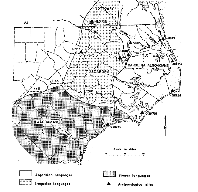
Geography and Archaeology
As
I've said, North Carolina is more of a "South Virginia" from the
perspective of European settlement. The
same is true from the Native American perspective as well. The North Carolinian Indians tended to belong
to the same linguistic groups as those in Virginia: Algonquian, Iroquoian, and
Siouan. The South Carolinian Indians on
the other hand—the Peedee and Cusabo and such—well, no one really knows what
languages they spoke, but it probably was something different.
Recall
from part 1 that in North Carolina the tidewater line cuts through the coastal
plain splitting it in half.
Incidentally, this also very roughly marked the border between the
Iroquoians of the upper coastal plain and the Carolina Algonquians of the lower
tidewater. I can't entirely explain why
such an unobtrusive natural boundary would be so determinative—some say that
the lifestyles of the two groups focused on harvesting different manner of sea
creatures who are sensitive to such things.
Or maybe the hassle of paddling upriver even during high tide simply
vexed the
thalassocratic Algonquians more than the landlubbing Iroquoians? Of course the border doesn't actually match the tidewater line on any
map I've seen—more of a guideline I suppose.

The Algonquians and
Iroquoians are also distinguished by their different classes of archaeological ware. Iroquoian sites are classified as belonging
to the Cashie phase, and Algonquian sites to the Colington phase. Since archaeology is still voodoo sorcery to
me, I can't tell you precisely what distinguishes the wares from the two phases—however one difference is that the Algonquian
used crushed shell fragments to temper their pottery (meaning they mixed the
fragments into the clay to prevent shrinking and cracking) whereas the
Iroquoians used sand.
This, part 3a, is about
the Algonquians. Part 3b will cover the
Iroquoians.
* *
*
§ 4. Secondary sources
The Carolina Algonquians
get much less attention than either their relatives to the north (the
Powhatans) or their rivals to the west (the Tuscaroras, who you usually get if
you search "North Carolina Indians"), and what little press they do
get is often sidelined by attempts to solve the mystery of the Lost Colony. However I've found three sources in
particular to be especially useful in constructing the borders of the Carolina
Algonquians.
My first source is Maurice Mook, Algonquian ethnohistory of the Carolina Sound (1944). Despite being almost eight decades old, it is
to my knowledge still the most detailed and thorough analysis of the Indian
tribes and the locations of their villages.
It includes a map:

My second source is David Beers Quinn, The Roanoke Voyages, 1584-1590 (1955). Quinn's commentary on village names and
locations is found in Appendix I. It
also comes with a map: this scan was made for me by a library out-of-state so I
can't attest to what the paper quality is like, or whether anyone could make a
better scan.
.jpg)
My third source is Bernard G. Hoffman, Ancient Tribes Revisited: A Summary of
Indian Distribution and Movement in the Northeastern United States from 1534 to
1779 (1967). Hoffman's article has a
much broader focus, and therefore he may have less specific insight regarding
North Carolina in particular—but he offers some corrections to Mook, and unlike
him his map has borders:

Mook, Quinn, and Hoffman
are my three main sources, and I cite them often.
For comparison, some
other maps—which are less useful, but still worth looking at:
Map from Frank Speck, The Ethnic Position of the Southeastern
Algonkian (1924). I have a lot of
respect for Speck, as he was one of the first who I'd call "modern
scholars" studying Native American history, but I seldom find myself actually using
his stuff:

Map from Bernard G.
Hoffman, Observations on Certain Ancient
Tribes of the Northern Appalachian Province (1964). This was the original article which Revisited is the sequel to, and the map
it comes with has numerous issues:

Maps from Lewis Binford
(1964 and 1967). Binford was the
recognized authority on the Indians of the Carolina sounds but—since he wrote
more on the culture of the people,
and I was just looking for locations—I didn't use him much as a source:

Similar things can be
said of Helen Rountree, a specialist in Powhatan history and culture. Her newest book on the Carolina Algonquians
(2022) is less focused on geography, but it does have a map (I've added the labels
from the key caption):
.jpg)
Map from Gerald P.
Smith (1971).

Some of these maps are
from sources concerned more with either the Virginia Algonquians or the
Iroquoians. For the Carolina
Algonquians, you can see that the uncertainties and disagreements increase as
you go south.
* *
*
§ 5. The Carolina Algonquian
"chiefdoms?"
The Algonquians of North Carolina
(sensu lato) were the Chowanoc, Weapemeoc, Secotan, Moratuc, Pamlico, and Neusiok. These were the
southernmost of all the Algonquian tribes, and the southernmost representatives
of the vast Algic phylum of languages which extends north into Labrador and
westward almost to the Pacific Ocean.
Let's set the Neusiok aside for now—I'll discuss them along with the
Coree in the final section below, as the Neusiok language is unattested and may
not have actually been Algonquian.
There's also good, reasonable doubt as to the affiliation of the
Moratuc, although I personally think they were Algonquians too (cf Goddard 2005). The Chowanoc and Weapemeoc languages are also
unattested, but anyone who seriously
doubts their Algonquianity is just being silly if you ask me. Only for Secotan and Pamlico do we have
direct and incontrovertible evidence that they spoke Algonquian dialects—I'm
using "Secotan" here to refer to the linguistic data from the Roanoke
expeditions, and "Pamlico" to refer to the Algonquian language
recorded by John Lawson in the 1700s.
I'm not really equipped to say whether these were even separate and
distinct languages. Linguists usually
just refer to it all as "Carolina Algonquian".
Being as they were, the Carolina
Algonquians were similar to their neighbors and relatives the Virginia
Algonquians, and this includes being ruled by chiefs. As among the Powhatan, the Secotan leaders
were called weroance, and as
elsewhere the English tended to refer to these weroances as
"kings". So for instance, the
Chowanoc were said to be ruled by a king named Menatonon, the Weapemeoc by a
king named Okisco, etc. The king of
Secotan and of Roanoke island was a man known as Wingina (later changed to Pemisapan)—it was he whom the Roanoke
colonists dealt with directly. He would
eventually be killed and beheaded on the orders of Ralph Lane.
 |
| John White painting of a weroance, believed to be Wingina. |
The Carolina Algonquians led
similar lives to those in Virginia and Maryland (in her book about them, Helen
Rountree will often supplement data from the Powhatan in cases where direct
info on the Carolinians is lacking). So
were they organized into chiefdoms and paramountcies, as the Powhatans and
Piscataways were? They may have been...
but the evidence is much weaker. Many
will say they were not. Wingina was weroance
of Roanoke and Dasamonquepeuc, so they say, but was not paramount chief of all
the Secotan; neither was Okisco of the Weapemeoc, et cetera. Rather these nations were alliances of
multiple chiefdoms, and if such a chief as Okisco had more credibility over his
fellow Weapemeoc chieftains, it wasn't because of his birth.
The problem is that we really
only have the Roanoke documents to go off of.
Because by the Albemarle era (1655+), the Carolina Algonquians had
become shadows of echoes of what they once were. The Weapemeoc had disintegrated into the
small bands of Yeopim, Poteskeet, Currituck, Pasquotank, and Perquiman (some of
whom may not have even existed, cf Mook 1944:221). The Secotan had dissolved into the
Mattamuskeet, the Hatteras, and the "Bay River Indians" (Mook 1944:223,
Garrow 1975:18). These tribelets
were all tiny in population. The
Chowanoc, Pamlico, and Neusiok survived, though similarly decreased in
number. The Moratuc evidently were gone.
It's not clear just what exactly
happened between 1586 and ca. 1700, and that makes it hard to interpolate the
data... balancing uncertainties on one end with other, different uncertainties
on the other. Thus it may be that the
Poteskeet, Pasquotank, etc. had originally been component tribes of the united
Weapemeoc, separating only when demographic conditions rendered such a large
chiefdom unsustainable. Or it may be
that there never was a single "Chiefdom of Weapemeoc", but the
Roanoke colonists merely assumed there was.
The Natives' subsequent population decline would have obscured the
matter in either case.
Roanoke colonists lacked the
vocabulary to give us a clear ethnographic picture, and "translating"
their feudal terminology into something that makes anthropological sense is
difficult. However, I hate and reject
the premise (implicit in some analyses) that the English were all just too
stupid to understand what they were seeing with their own eyes—that they
"only saw what they wanted to see" or other such wastrel. It's also worth saying that, being subjects
of Her Tudor Majesty, they did know a thing or two about the day-to-day reality
of living in a monarchy. And an
Algonquian chiefdom is a monarchy of sorts,
even if its parameters are different. If
the English said that Wingina was a king, then that clearly means... well, something anyway.
On the other hand, though they did
call them kings, the English did not refer to any of the chieftains as an
"emperor". The Powhatan
mamanatowicks, the Piscataway tayacs, the Nanticoke tallecks—even the
non-hereditary teethhas of the Tuscaroras—were all called emperors at one time
or another. Does it mean anything that
the chieftains of the Roanoke era weren't?
Did Wingina lack the power and splendor to merit such a title? Or are we just talking about the whims of
different sets of Englishmen, using imperial titles in very vague ways? The answer to the last question at least is
yes.
As Michael Oberg says,
"analogizing from what we know about the better-documented Algonquian
Powhatans is risky" (2020:584).
Oberg argues that there were no chiefdoms here, but he uses very strict
definitions of chiefdom and tribe.
The only author I found who explicitly says that the Carolina
Algonquians were entire chiefdoms and not
tribal alliances is Patrick Garrow (1975:16).
Most others seem to adopt a middling position where they might refer to
a "chiefdom of Secotan" or a "chiefdom of Chowanoc," but I
don't get the impression that they mean anything too specific or technical by
it—it's just a label. I do this as well.
The Chowanoc have the best claim
to being a true chiefdom: accounts make it out to be the largest and most
elaborate of the Carolina Algonquian nations.
Binford (1964:110) interprets the Roanoke documents as saying that the area
of Chowanoc was split into two divisions with a separate king over each: the
aforementioned Menatonon was king of one, and someone called Pooneno was king
of the other. Binford explicitly states
that the Weapemeoc and Secotan were not Virginia-style
paramountcies, but seems to accept that Menatonon and Pooneno were in fact true
chieftains and not just primi inter pares. Mook disagrees: he says that the document in
question is confused, and that Pooneno was subordinate to Menatonon. If so then this apparently makes Chowanoc fit
the definition of a paramount chiefdom as given by David G. Anderson [note E].
We will never know for sure. For the record I do think that at least some of
these groups were paramount chiefdoms, with the usual caveats applying. But since this is not firmly established, I
don't label anything a "paramountcy" on my map.
* *
*
§ 5.1 The Chesepioc, Chowanoc, and Weapemeoc
Beginning from the north, the
first chiefdom described by the Roanoke colonists was Chesepioc situated at the entrance to Chesapeake Bay—I covered them
already in part 1. Three other tribes
are briefly mentioned as neighbors of the Chesepioc: the Mandoag, the
Tripanick, and the Opossians.
"Mandoag" is probably a mistake for "Mangoag" i.e.
the Iroquoians to the west, though some disagree. As for Tripanick and Opossian: some have said
they refer to groups later found within the Powhatan paramountcy, perhaps the
Nansemonds or the Warraskoyacks.
"Opossian" does very vaguely resemble "Potcheack", a
later alias of the Nansemonds (cf. Stanard:1900), but honestly I don't think
there's anything to be found in these names.
There were several tribes and
chiefdoms whose borders ran parallel to or intersected with the Chowan River,
and in order to locate them it's necessary to identify and locate the major
settlements built along this river. On
the west bank these were Ramushouuōg,
Chowanoac, Ohanoak, Metackwem, and Tandaquomuc. A few others were located on the east bank,
but they tend to jump around a lot between maps so it's hard to know exactly
which, or how many, were on the Chowan.
This section is a little weedy with archaeological site designations,
but hopefully this map will keep things a little clear: dots are archaeological
sites, and all locations are colored blue for Colington sites or sites
otherwise associated with Algonquians, and red for Cashie/Iroquoians.

On the De Bry map, the Chowanoc town
of Ramushouuōg [some read <Ramushouuōq>
but the last letter is clearly a 'g'; for some reason Quinn suggests an
intended <Ramushonnouk>] is located on the inner corner of the
Chowan-Meherrin confluence—this corner was later termed the "Meherrin
Neck" after a group of Meherrin moved there in the 1680/90's. The Meherrin occupation is known from the
Cashie-II archaeological site designated 31Hf1 (or just "Hf1"—in
Smithsonian Trinomials all North Carolina sites begin with "31"),
however Mook and Hoffman believed that at the time of the Roanoke colony Ramushouuōg
belonged to the Chowanoc (Smith 1971:161 differs). That the Meherrin Neck had once been Chowanoc
territory was remembered by the English of Carolina during their later border
dispute with Virginia (Dawdy 1994:81) [note F].
Continuing down the Chowan River
on the west side, the next two towns of note were Chowanoac and Ohanoak—both
Chowanoc settlements. Several of my
sources agree that Chowanoac was in the vicinity of Taylor Pond creek (aka Deep
Swamp Branch?) and a cluster of sites designated Hf19, 20, 23, 24, 28, and 30 (Mook
1944:190, Petrey 2014:196, Wilson 1977:17, Mintz &al. 2011). Ohanoak was either upstream or downstream
from here, depending on who you ask. One
school of thought locates it upstream, at site Hf11. Shannon Lee Dawdy mentions that there is
"local tradition" which claims that the Hf11 area was
the location of Ohanoak, but I put almost no stock in this. The better argument for Hf11 is that it fits
much better than Br3 according to the De Bry map—this must be the reason why 20th
century archaeologists favored it (cf Wilson 1977:17).
However, Mook was critical of using the De Bry map in this way at the
expense of the supposedly more accurate written account of Ralph Lane: the
latter he says (and I agree) "clearly locates" Ohanoak downstream
near the present town of Colerain (p.191). My
other modern historical (Quinn, Hoffman, Rountree) and archaeological (Mintz et al.;
Petrey) sources concur that the Colerain area (site Br3) was the
likely location of Ohanoak.
Curiously, one important piece of
evidence is almost never brought up in the context of locating Ohanoak: the Nicholas Comberford map of 1657. This map (which is not obscure, though it is damned impossible to find an edition
with readable labels) was created using information learned from Nathaniel
Batts, one of the earliest permanent white settlers in the region—I think he's
known in NC as being the "First North Carolinan" or something. The Comberford map is one of only two maps I
know which provide fresh information on the Carolina Algonquians during the
elusive intercolonial period.
 |
| Map of Nicholas Comberford, 1657. |
It's not always clear on these
old maps which tributary is supposed to be what, but there is one feature of
the Chowan River which is entirely unambiguous: Holiday Island, the little eyot
located on the first bend of the river.
This eyot isn't visible on White's map, but both the Comberford and De
Bry maps clearly show Ohanoak ("Wohanock" on Comberford) as being upstream of it. Colerain is downstream of Holiday Island.
This means that Ohanoak must've been at site Hf11,
right? Very likely... however, there is
reason to think that the village may have been relocated (they did that
sometimes) at some point between 1585 and the 1650s—see below in section §6 for
that, and for the western border of the Chowanocs.
 |
| "Wohanock" on the Comberford map. Taken from Cumming, The Southeast in Early Maps using my iphone and a magnifying glass. |
The Weapemeoc tribe controlled an area which in later periods was
occupied by the Yeopim, Poteskeet, Currituck, Pasquotank, and
Perquiman—although Mook questions whether all of these groups even existed, or
if some have been invented from the names of North Carolina counties. The name "Yeopim" is more-or-less
identical to "Weapemeoc" minus the Algonquian plural suffix –ak, so perhaps they had once been the
dominant (and therefore eponymous) element within the Weapemeoc
tribe/chiefdom/whatever.
I assume that the
boundary between Weapemeoc and Chowanoc territory roughly followed the boundary between the watersheds of the upper
Chowan River and the Albemarle Sound.
This border reached the Chowan River somewhere upstream from the
Weapemeoc village of Mascomenge where the city of Edenton now stands (Mintz et
al. specifically link Mascomenge to site Co30, but I can't find
anything else confirming that site's existence
much less its exact location). A few
other villages may or may not have been in the Edenton area as well, depending
on which author you ask. Several
Colington-phase sites cluster in that area, though I can't say how many were
active in the late 16th century.
Upstream a bit from Edenton
on the Chowan River are two sites: Co14 and Co15. I have not seen any archaeologist link them
to an Algonquian village, but they are in the same location as Warowtani
according to Mook, or Ricahokene according to Feest and Rountree... or they
could be nothing. Further upstream, site
Co1 has
been linked to either Warowtani or the village of Cautaking (Mintz et al.
2011:5, Petrey 2014:60). The
Comberford map shows Cautaking ("Katoking") somewhere in this area
but it's hard to tell exactly where. Quinn
critiques Mook for placing Warowtani and Cautaking so far north, saying that he
relied too much on the De Bry map at the expense of the presumably more
accurate White map. More importantly,
though, Mook's position was that if Warowtani and Cautaking were so far north,
they must have been Chowanoc towns rather than Weapemeoc. So both the pro- and the anti-Mook position would
agree that the area of Co1 and upstream of it was probably not Weapemeoc (though Co14/15 may
have been).
The Reverend James Geary
provided Quinn with an Algonquian etymology for Ricahokene ("place where
combs are made"), but I personally cannot accept this since the name is
almost identical to Rickahockan, a later tribe whose name (cognate with
"Erie") is Iroquoian for "people of the cherry tree place"
(something like [e]riʔkehakaʔ). Rather than being a village of Weapemeocs,
the Ricahokenes were a wandering Iroquoian group—they were later found in
Virginia by 1608, and subsequently fled west over the mountains (cf Hann 2006:54)
[note G]. Therefore the area
around sites Co14/15 was not necessarily
within Weapemeoc territory, but it does sound like the Ricahokene were
associated—at least politically—with the Weapemeoc chiefdom.
 |
| Map of John Lederer, 1672. Note "Rickohockans" in the mountains. |
Sites Co14 and Co15 are
located on a stream called Rockyhock Creek, no doubt named for the
Ricahokene/Rickahockan; on the Comberford map the people living here are called
the "Rockahock". So it's quite
unlikely that Christian Feest is wrong in locating them here... despite the
migrations aforementioned, at least some Ricahokenes must have stayed long
enough to meet Nathaniel Batts in the 1650s.
Less secure than the Ricahokenes' location is their affiliation: if they
were a wandering Iroquoian group, then cultural and linguistic differences
might have kept them apart from the "other" Weapemeoc villages. Lars Adams, in his article on the 1670s'
Chowan River War, maps the Rockahock village within Chowanoke territory—he
doesn't elaborate on why. However, the
Chowanoc don't seem to have suffered such a disintegration as the Weapemeoc did
in the 17th century: a possible motive for the Ricahokene changing sides?
 |
| Map from Adams 2013. |
The Weapemeoc also controlled
a strip of territory west of the Chowan River, including the village of
Metackwem—which I have seen connected to four different sites: Br38 (Wilson
1977:22), Br45 (Petrey 2014:60), Br49, and Br56 (Mintz et al. 2011). This strip was bordered by the Chowanoc to
the north, and to the south by the village of Tandaquomuc whose affiliation is
obscure but which Hoffman, at least, seemed confident in assigning to the
Moratucs.
Under the circumstances
I think what I'm going to do is draw the border between Chowanoc and Weapemeoc
north of Rockyhock Creek (Co14/15) and south of Co1 and Colerain
(Br3). Even if site Br3 was
not Ohanoak, it may still have been a Chowanoc site. Site Co1 is almost directly
opposite the river from Colerain, and clusters more with other Chowanoc sites
especially if you consider the waterways so favored by coastal
Algonquians. But since I'm not
entirely confident in this, I will nudge the border a little to the north, say
twice as close to Co1 than to Co14/15. "Splitting the difference" in this
way probably makes as much sense as the joke about the three statisticians who
went duck hunting, but ehhh... it is what it is.
 |
| Probable village locations on the lower Chowan river. |
§ 5.2 The Moratuc, Secotan, and Pamlico
The De Bry map is the
only document which names the village of Tandaquomuc, and I think this shows
that the map can be treated as a reliable source. Theodor de Bry may have been wrong about a
village's name or location, but it seems unlikely that he'd just make one up—someone must have told him. I didn't find anyone connecting any
archaeological sites to Tandaquomuc, but it does match the location and
approximate date of site Br1 (cf Petrey 2014:60).
On the De Bry map, the
village of Moratuc is on a large oxbow bend of the Roanoke River. Hoffman's and Quinn's maps both place this on
the first big meander of the Roanoke; Mook's map places it on the next meander
upstream. This needn't worry us, because
as it happens both locations contain
Cashie-phase archaeological sites: Br5 "Sans Souci"
on the first meander, and Br7 "Jordan's Landing"
on the second. The Moratuc are supposed
to have been Algonquian, whereas the Cashie series is associated with
Iroquoians. This might compell one to
suppose that the Moratucs were actually Iroquoians [note H], or that they
were Algonquians who nonetheless produced Cashie artifacts—neither is
impossible. However, the radiocarbon
dates from Jordan's Landing most likely predate the Roanoke-era Moratucs,
perhaps by centuries, and Sans Souci seems to be rather old as well (Killgrove
2002: 48-51, Heath & Swindell 2011: 17-18; Phelps & Heath 1998:6). I take this to mean that they were once
Tuscarora villages which were later taken over by Algonquians. Or they may have simply been prime locations
to build a village on.
The town of Mequopen was
somewhere in the northern Secotan peninsula.
On the De Bry map, Mequopen seems to be in the same location where Moratuc
is on both of the White maps. However I
am suspicious of how the De Bry Map—and not
the White maps—accurately depicts the excessive meandery-ness of the Roanoke
River, so I'm not willing to just toss out the De Bry map here on the
assumption that White's maps are always superior. This may be a case where John White conveyed
corrected data to Theodor de Bry.
Mook implied that Mequopen
belonged to the Secotans, but Hoffman said it was "possible" they
were Moratuc; Quinn said they were "unlikely" to be Secotans and that
they (and the Tandaquomuc) likely "belonged to a tribe occupying the
southern shore of Albemarle Sound and the swamp-forest behind". If this is some other tribe separate from all
the rest, then Quinn's speculation here is the only indication of its existence
given by any of the authors, past or present.
For the sake of parsimony then, it's best to assume that Mequopen was a
Moratuc village. According to Hoffman,
Mequopen was just east of Roanoke River or Mackeys Creek, but everyone else
locates it on Scuppernong River, and I agree that that is what it looks like on
the De Bry map.
Since there is some
uncertainty regarding the location and the political affiliation of Mequopen, I
have drawn the eastern border of the Moratuc along Scuppernong River, even
though such rivers were seldom used as political boundaries for the eastern
Indians... more duck-hunting statisticians, I'm afraid.
*
In the fullest
interpretation, the Secotan domain
included most of the Secotan peninsula and the northern Pamlico-Neuse
peninsula, as well as Roanoke Island where Ralegh's colonists settled, and Hatteras
Island a.k.a. Croatoan of "carved into a post" fame. Like the Weapemeoc, the Secotan dissolved
into separate tribes by the late 1600s, into the Machapunga/Mattamuskeet, the
Roanoke, the Hatteras, and the so-called "Bay River-" or "Bear
River Indians".
The White and De Bry maps
show three towns in the southern, "core" Secotan region, and the
names of these towns don't exactly make sense.
Two of them—"Secoton" and "Secotaóc" per
White—appear to have the same root, only inflected with different endings (someone
suggested a reflex of Proto-Algonquian *-o·te·nayi
"town" for a toponym and a reflex of *-ote·waki "they well" for a demonym). The third town "Seco" would then be
the uninflected root, but that wouldn't explain why De Bry calls it
"Cotan". Quinn says that
White's "Seco" may have been influenced by a Dry Driver or Rio Seco from earlier Spanish maps.
Altogether I don't get
the impression that the English knew a whole lot about this area, but the
Natives here were probably the ancestors of the later Bay River Indians. Wesley Taukchiray says that the 18th
century "Bay River" was actually the modern Pungo River (p31),
but I can't find any corroborating evidence for that. No contemporary map I know of ever calls the
Pungo the "Bear River" or "Bay River": on the contrary, the
Pungo is called the "Machapounga" as early as the 1657 Comberford map.
The first map to show a "Bay River"
is Lawson's of 1709, where it's identical to the modern Bay River. In fact Taukchiray quotes a letter from 1716
which refers to "the nation called Marosmoskees living formerly in the
North of Renoque" (p56).
Assuming that Renoque is the same as Radauqua-quank (a village of the
Bear River Indians according to Lawson), then this description would make more
sense if that "Bear River" was the modern Bay, not the Pungo.

"Adioyning to this
countrey aforeſaid called Secotan," saith Arthur Barlowe, "beginneth
a countrey called Pomouik, belonging to another king whom they call Piemacum,
and this king is in league with the next king adioyning towards the ſetting of
the Sunne, and the countrey Newſiok, ſituate vpon a goodly riuer called
Neus" (Hakluyt 1600:III:250). Now
that description doesn't make a lot of sense, until you consider that what Barlowe
thought was west might've been closer to southwest. For some reason a lot of early mariners on
the Atlantic coast got disoriented this way: you can see it on some of the
maps, and elsewhere in Barlowe's account where he is describing Ocracoke Island.
The borderland between
Secotan, Neusioc, and Pamlico [=Pomouik] is so little known that you can't
really blame modern map reconstructions for not bothering to try and put
borders down. That being so, I can do
little better than to just copy Bernard Hoffman.
* *
*
There are disagreements
concerning the size and extent of the Secotan chiefdom/confederacy. While the orthodox view is as aforementioned,
there are dissenting voices which say that Roanoke, Secotan, and Croatoan were
separate. Lee Miller devotes Appendix A
of her book Roanoke: Solving the Mystery
of the Lost Colony entirely to this question, and her conclusion agrees
with the orthodox view that Secotan did include Roanoke:
"The
primary evidence ... presents a convincing picture of Wingina as paramount
leader of the Secotan, whose territory included Secota (the chief town),
Aquascogoc, Pomeioc, and the towns of Dasamonquepeuc and Roanoke at the very
least, and portions of the Outer Banks and Washington and Tyrrell Counties as
well. The evidence does not sustain a
picture of a Roanoke tribe separate from the Secotan..."
(Miller
2012:269)
Miller is here mostly
responding to David Beers Quinn (1985:44).
She doesn't specify if Croatoan was also a member of Secotan, but Quinn suggests
it was—and if he is the more minimalist of the two then perhaps it's safe to
conclude that Croatoan was a member of the Secotan chiefdom, at least in 1585. Ocracoke Island certainly seems so, at least
in Arthur Barlowe's narrative, and it's right next to Croatoan.
Another dissenting view
is that Pomeioke was a separate chiefdom, sandwiched in between Secotan and
Roanoke (who were also separate). This
is the view of Helen Rountree (2021) and Michael Oberg (2020)—to some people the
fact that these works are far more recent than the rest might mean they're more
likely to be correct, but in my view modern scholarship stands alongside earlier scholarship, not
overtop it. Without getting into the
weeds of it: my reading of the primary sources makes it clear that Pomeioke was
not an independent chiefdom; Secotan was
more plausibly independent, but Barlowe at least implies that it was not. Rountree herself inadvertently(?) gives
support for the unity of greater Secotan, in when she lists off the major
chiefdoms and their rulers (my emphasis in bold and italics):
"Croatoan: No
chief was named, which is more evidence
of its being a camp within some other chiefdom. Manteo and Wanchese came from here.
Chowanoke: The chief was Menatonon, but we cannot be
certain whether he was that group's overall chief or only chief of the upriver
towns, while Pooneno was chief of downriver ones.
Pomeioke: The chief there was Piemacum.
Roanoke: The chief was Wingina, who changed his name
to Pemisapan after his brother died (before April 1586). The brother, who governed in his absence, was
Granganimeo, and his father's name was Ensenore (who, by the rule of chiefly
inheritance, was not himself a chief).
Secota: No
chief's name was recorded.
Weapemeoc: The chief was Okisko. The satellite town of Chepanoke was governed
by an unnamed woman, so the English called it "the woman's
town.""
(Rountree
2021:81)
Huh... No chief's name recorded for Secota, you
say?...
It's worse than that
though, because the Pomeioke line should say "no chief's name
recorded" as well... except that Rountree is somehow confusing Pomeioke
with Pomouik. Both locations are named
in the account of Arthur Barlowe and it is quite clear that they are meant to
be two different places—and Barlowe is unambiguous in saying that
"Piemacum" was the ruler of Pomouik
[or "Pomovik" in the 1904 edition].
He locates this Pomouik in the same area where the De Bry map locates
the village of "Pannauuaioc".
That name, for the record, also appears via Powhatan sources in the
writings of John Smith ("Panawicke", "Panawiock") and
William Strachey ("Pannawaick"), so that gives you an idea of what
the word sounded like to the Englishmen and how they were wont to spell it (cf Barbour
1975). This is why most
people—myself included—believe that Barlowe's "Pomouik" is an error
for "Ponouik".
Rountree's confusion of
Pomouik and Pomeioke may also be why she adopts the strange position that it was
the Pomeioke—and not the Pomouik/Pannauuaioc—who were the ancestors of the
later Pamlico. Unfortunately she and her
coauthor Wesley Taukchiray choose to not give any explicit rationale for this,
so I'm forced to conclude that it's the superficial resemblance between
"Pomouik" and "Pamlico" (they both sort of go
<Pam...ik...>) compounded by the misreading of Barlowe that conflates the
Pomouik with Pomeioke.
 |
| Painting of Pomeioke by John White. |
The name
"Pamlico" doesn't occur in the Roanoke documents; it comes from the
17th century, and has two variants—one with an L as in Pamlico, and one with a
T as in Pampticough. Of the two, the T
variant is probably the original. I
haven't done a comprehensive search, but the first L variant spelling I could
find in the Colonial Records of North
Carolina was "Phampleco" in a text from 1681 (vol I:228). This is preceded by several maps which use
the T spelling: "Pemptico" on the Ogilby map of 1672,
"Panticoe" on the Horne map of 1666, and what I think is "Pamxtico"
on the Comberford map of 1657—though that last one is really hard to read.

Unfortunately William
Bright's Native American Placenames of
the United States doesn't give any etymology for "Pamlico" or
"Pampticough". But it was
suggested to me by an acquaintance that it may be cognate with the word for
"river" in Nanticoke: recorded as pamptuckquah!,
peemtuk, or pèmp-tugu [note I].
This resembles neither Pannauuaioc nor Pomeioke nor any variant spelling
thereof—nay, it's a different word entirely.
This is why it's no use squinting at the names in the Roanoke documents
trying to find a resemblance.
A meaning of
"river" is plausible, since the earliest tokens of
"Pamlico" and its variants all refer to the Pamlico river, not the Indian tribe—I couldn't
find any early text which explicitly locates the Pamlico Indians prior to their
removal to the Mattamuskeet reservation.
Whoever they were they must have lived along the Pamlico river and were
later named after it—much like the Bay River Indians. This puts them in the same location as the
Panauuaioc, and since both tribes otherwise lack a counterpart across the Roanoke-Albemarle
divide, they must have been the same. One
might object that since the Pomeiokes lived along the Pamlico sound, then perhaps they could have been named after it? But contemporary maps show that the people of
that time did not conceive of the Pamlico River as gradually opening up into
the sound as one continuous body of water.
Instead, the river is depicted abruptly debouching into the sound's
western end, and anyway they didn't even call it the Pamlico Sound either, it
was just "the Sound".
 |
| John Speed map, 1676. |
All of this I take to
mean that the Pomouik were the Pannauuaioc; that they were the same people as the Pamlico even though that name is at least partially unrelated;
that they were not the same as the
Pomeioke; and that both the Pomeioke and the various "Secota" towns
were under the umbrella of the Roanoke chiefdom—even if it was a
"chiefdom" in only a very loose sense.
* *
*
§ 6. The Situation in 1600
Gerald P. Smith's
dissertation on the Nottoway has a comment about the Carolina Algonquians which
caught my eye:
"The
situation found by White in the Pamlico Sound area upon his return in 1587 is
not very helpful. At this time White [...]
found it necessary to have the people of Croatan intercede for him with Secota,
Aquascogoc, and Pomiock. He appealed to
them to accept English friendship with the mutual grudges of both sides to be
forgotten. There appears to have been no
overall ruler of these towns, but simply ruled by independent town
headmen. The remnants of Wingina's
people had driven off 15 Englishmen left by Grenville after Lane's departure
with Drake and then abandoned Dasemunkepeuc.
What became of Wingina's people is unknown; they may have dispersed
among several towns or have gone to Weapemeoc.
They apparently were no longer dominant over the southern towns. The intended appropriation of any surviving
crops at Dasemunkepeuc by the Croatan suggests Roanoke abandonment of the immediate
vicinity, probably through fear of English vengeance. Any formal political tie between the northern
and southern towns seems to have been dissolved by this time."
(Smith 1971:158)
In other words, the
subregions of Roanoke, Croatoan, Pomeioke, Secota, and Aquascogoc had all been
united in 1585. But the unique character
and centripetal charisma of high chief Wingina were essential to keeping it
together, and after his murder by Ralph Lane & company, the union of greater
Secotan was shattered.
It is appealing in this
view to see Wingina as a counterpart to his contemporary Wahunsonacock of
Powhatan: both chieftains in the process of nationbuilding, of absorbing and
uniting many different local chiefdoms into one overarching paramountcy. It was said that the Powhatans modeled their
political institutions after the Piscataway, and the Piscataway modeled theirs
after the Nanticoke. And note that the
Chowanoc chiefdom was more powerful, centralized, and resilient than the others
of Algonquian Carolina. Clearly the
whole "paramount chiefdom" thing was in the process of spreading
southward in the 1500s. The Secotans may
have been next in line? Perhaps if
Wingina had had a successor strong enough to fill his shoes—an Opechancanough
to his Wahunsonacock—then the process could have continued. But that didn't happen.
Why does this matter? Because remember, my main goal here is to
make a map for circa 1600, not 1585. So
how had things changed by then?
Unfortunately I can't appeal directly to anyone else's work; no one else
has asked what the Carolina Algonquian territories were in that specific year,
and why would they? So in this section I
have to do some theorizing, hypothesizing, and speculatizing of my own—it is
unlikely that all of it will be correct.
The narrative of Francis
Yeardley describes visits to and by the Roanoke in the years 1653 and '54 (Salley 1911). His account makes it clear that the chieftain
of Roanoke controlled more than just the island at that point—in fact he's
described in the text as the "emperor" of Roanoke, being an exception
to the aforementioned naming trend.
Unfortunately it's not clear which parts of the mainland his chiefdom
contained: the text almost makes it sound like it included the waters of the
Currituck Inlet, which might be wrong. But
doubtless it at least included the mainland adjacent to the island—which is to
say that the Roanokes had regained control of Dasamonquepeuc, likely decades since. Yeardley mentions several "great
men" of the "provinces" in ways which imply that the Roanoke ~empire~
at this point was more an alliance of local chiefdoms. This would be consistent with what apparently
happened with the Weapemeoc.

Gerald P. Smith's map depicts
the remainder of the Secotan chiefdom as a single "sociopolitical
unit" circa 1607. In other words,
he apparently doesn't think that Croatoan, Pomeioc, Aquascogoc, and Secotoac
etc. had all gone their separate ways after the death of Wingina—though there's
no saying what manner this "sociopolitical unit" was, if he's
right. Minus the Croatoan, that area is
roughly equivalent to the later haunts of the Mattamuskeet/Machapunga and Bear
River Indians—both groups together are at least sometimes referred to as
"Mattamuskeet", and I will opt to label them thus on my map. I could call them "Secotan" but
then—if I ever make a chronological map—that would open the pointless question
of exactly when they stopped being Secotans and started being Mattamuskeets.
* *
*
The country to the west
of the Chowan river also underwent changes in the intercolonial era, being a
theater of war between the Chowanoc and the Tuscarora. Presumably the Moratuc too were involved.
The entire strip
adjacent the river, from Ramushouuōg to the mouth of the Roanoke, was in the
hands of the Algonquians in the 1580s.
By 1644, however, the situation had changed: at that time, during the
Third Anglo-Powhatan War, members of the Weyanock chiefdom broke away from the
Powhatans and fled south into North Carolina, settling in the country west of
the Chowan. This historical event ended
up being relevant to a boundary dispute between Virginia and Carolina, and in
the early 1700s several depositions were taken (from mostly elderly Englishmen,
Nansemonds, Meherrin, and Chowanoc) regarding the details, later collected and
published as The Indians of Southern
Virginia in 1900. The deposed
witnesses mostly agreed that when the Weyanocks migrated south they purchased
the territory west of the Chowan river from the Tuscaroras (not from the Chowanoc,
Weapemeoc, or Moratuc). The Algonquians
had evidently all been driven out (cf Parramore 1982:311).
How much of this strip
was actually overtaken by the Tuscarora, and when did this conquest take place? The tract bought by the Weyanocks was said to
have extended from the Roanoke River to the mouth of the Meherrin—however, some
statements in the depositions suggest that it only went up to Wicacon Creek. Subsequent events show that the Chowanoc
still controlled the land above this
creek until their defeat in the Chowan River War of 1676-7 (Adams 2013). Recall that the Comberford map shows that the
town of Ohanoak still existed along the upper Chowan river in 1657. If the Tuscaroras had invaded the lands below
Wicacon Creek, then the Chowanoc would have fled upstream. And if Comberford's "Wohanock" was
as far upstream as Lars C. Adams believes it was (too far to be at site Hf11), then
the village may have been relocated—perhaps from the Br3/Colerain
area. The absence on the Comberford map
of Chowanoac, Metackwem, and Tandaquomuc suggests that these towns too had been
destroyed or forced to relocate.

The Englishman John Pory
visited the Chowanocs in 1622, and although his own account is not available, other
writings refer to him crossing south of the Chowan river and visiting the
"Choanoack" (Powell 1977:100).
Assuming that to be the town and not just a reference to the tribe in
general (they are in fact the same name), then this means that Chowanoac was
still standing at that time. It probably
wasn't directly threatened until after 1632,
when the Powhatans lost their second war with the English and had to reduce
their support for the Chowanoc against the western Indians (Parramore
1982; he writes "1622" but it looks like an error for 1632). However, the Tuscarora invasion had likely
already been progressing by then.
Remember how I said that
the Comberford map is one of two maps that show fresh information for the
post-Roanoke, pre-Albemarle period? Well
the other such map is the so-called Smith/Zuñiga map of 1608. Its exact provenance is a little unclear, but
it may have been copied from an original map by John Smith. The information on the map came from
Powhatan-speaking sources, and the names it uses for the North Carolina area
tend to differ from the names we've been using and therefore aren't very
helpful (the reverse is also true: John White's map using Carolina Algonquian
names for the Chesapeake Bay region).
The geography isn't very good either, but you can at least make out the
Chowan, Roanoke, Pamlico, and Neuse rivers.

People usually bring
this map up because one of the captions seems to say what happened to the Lost
Colonists. But another caption shows a "morattico"
on the southern shore of Pamlico River: far from their location 20 years
earlier. This might just be a
mistake. But on the 1657 Comberford map
a "Morataux" is shown on Bennett's Creek north of the Chowan—which is
also a completely "wrong" place.
So maybe these aren't mistakes, and the Moratuc were in fact a
dislocated and wandering people. The
conclusion then is that by 1608, the Tuscaroras had already driven the Moratucs
from their former lands on the Roanoke River.
To this I might add that the Tandaquomuc region is one of the plausible
locations for the Lost Colonists to have relocated after 1587: a biological
bomb planted in the heart of Moratuc country?
 |
| Hidden icon of a fort on John White map. Picture from Artnet News. |
Lost Colonists or no
Lost Colonists, though, the balance of the region could have been destabilized
by the whole Roanoke venture and the death of chief Wingina. If so then the dispersal of the Moratucs was
likely sooner rather than later within the 1586-to-1608
interval. I'm guessing the Tuscaroras
had already descended the Roanoke by 1600.
These hypotheses are
wide open to criticism. I have to grasp
at whatever straws I can find to try and date the changes that happened in the
intercolonial period. Two especially
tenuous assumptions I make here—1: that the northwest of the Secotan peninsula
was repopulated by the Roanokes after the dispersal of the Moratucs; and 2: that
the western border of the Algonquians in 1585 was also the border of the
Weyanock land grant in 1644 (assuming also that the town of
"Towaywink" on the Roanoke river where the Weyanocks settled was in
the same location as the old town of Moratuc in 1585). These make intuitive sense to me but are really
no more than guesses.
 |
| Conjectural reconstruction of the Tuscarora conquest of the Chowan. |
* *
*
§ 7. The Southern Periphery: Neusiok and Coree
The Neusiok are the last and southernmost Algonquian group in North
Carolina. Or rather, they might be—calling them Algonquians tends
to be accompanied by an implicit little tap on the nose, since the Roanoke
colonists didn't interact with them at all and there is in fact no evidence
whatsoever for what kind of language they spoke. The same is true, or nearly so, for the Coree who were the next Indian group
south of the Neusiok—the Coree inhabited the coastlines of Core Sound and Bogue
Sound, and probably some distance further though here our knowledge gradually
fades into smoke.
It's difficult to say much with
certainty about either the Coree or the Neusiok. Neither tribe is well known
historically: they appear in the records
of the Roanoke colony although as far as I know they had no contact with them,
and later they occupied minor roles in the Tuscarora War and events leading up
to it. Not long after the war both
groups disappear from the historical record, and consequently not a whole lot
is written about them. A couple modern
books devote a few pages each to the Coree: Brandon Fullam's The Lost Colony of Roanoke: New Perspectives
(2017:
pages 78-81) and David La Vere's The
Tuscarora War (2013: pages 58-9).
Together with bits of Mook's article these are the fullest treatment of
Coree history I know—even the Handbook of
North American Indians allots them only a couple of lines.
The Coree went by a few
names. "Coree" itself was also
spelled "Core" and it's not certain which spelling better reflects
how the English pronounced the name: the modern local pronunciation in
placenames like "Core Sound" is as one syllable (Goddard 2005:n33). To the Roanoke colonists they were known as
the Cwareuuoc, which is Algonquian for "the people of Core"—Goddard
suggests something like kwa:ri:wak. The same <cor> root is found in "Coranine"
which is the name they went by in the late 1600s. That is how John Lawson usually referred to
them, however in one place in his book he clarifies that Coranine (and Raruta)
are merely names of villages, and
that the entire tribe is called Connamox. The latter name pops up in another document
from 1703 as "Connamocksocks" which is the same plus a couple extra
Algonquian and English plural suffixes (Taukchiray 1983:30) [note J].
 |
| "The Coranines" on Neuse peninsula on the Comberford map. As far as I know it is the first attestation of the name "Coranine". |
The Neusiok and Coree territories
seem to have been undifferentiated by around 1700. Around that time both tribes had villages
within the diamond between the Neuse and Trent rivers—one Neusiok village named
Chatooka in the eastern corner where
the town of New Bern was later built, and two presumably Coree towns named Coram
and Corutra upstream on the Neuse. One
of those may have been the same place otherwise known as Core Town, located somewhere on the Neuse between New Bern and the
embouchure of Catechna Creek [note K]. In
1709 John Lawson records Coranines at the tip of the Neuse peninsula
overlooking Cedar Island, and a Neusiok village Rouconk which may have been approximately where the earlier Neusiok
town of Marasanico was located (Mook 1944:219).
 |
| John Lawson map, 1709. |
Lawson's book also has this
peculiar passage:
"This Morning, we ſet out
early, being four Engliſh-Men,
beſides ſeveral Indians. We went 10 Miles, and were then ſtopp'd by
the Freſhes of Enoe-River, which had
rais'd it ſo high, that we could not paſs over, till it was fallen. I enquir'd of my Guide, Where this River
diſgorg'd it ſelf? He ſaid, It was Enoe-River, and run into a Place call'd Enoe-Bay, near his Country, which he
left when he was a Boy ; by which I perceiv'd, he was one of the Cores by Birth : This being a Branch of Neus-River."
(Lawson 1709:58)
This only makes sense if we
assume the middle-lower Neuse river was considered part of the Eno river,
contrary to the modern hydronymy. Still
though, why did he conclude his guide was Coree rather than Neusiok? The disgorgement of the Neuse river is much
closer to the two Neusiok villages than it is to either Core Town or the Core
Sound. This is also the only place in
his book where Lawson refers to the tribe in question as "Cores", as
opposed to Coranines or Connamox. It's
almost as if he considered "Core" to be a broader category including
both the Coranines and the Neusioks?
However, Chatooka was still a
relatively new installment as of 1710, when the Baron von Graffenried bought
the land from the Neusioks to build his settlement of New Bern—according to
Mook, those Neusioks had only recently moved from the southeast; Fullam and La
Vere say the same of Core Town. The maps
of White and De Bry, such as they are, also show an apparently more clear-cut
division between the Neusiok and Coree territories. Thus the situation around 1700 was not what
it had been in 1600 or 1585.
* *
*
The Coree and Neusiok languages
are completely unattested and—since they were hemmed in by the Algonquians to
the north, the Woccon to the northwest (who were Siouan, or specifically
Catawban), and by various Carolina tribes to the southwest (whose languages are
unknown)—it's difficult to even guess at what their languages were like. One sometimes sees an author state authoritatively
that they definitely spoke
Algonquian, or that they certainly
spoke Iroquoian, or that it's a sure
thing they spoke Siouan... but this is bullshit. The only real evidence we have is this
statement from John Lawson:
"I once met with a young Indian Woman, that had been brought from
beyond the Mountains, and was ſold a Slave into Virginia. She ſpoke the ſame
Language, as the Coranine Indians,
that dwell near Cape-Look-out,
allowing for ſome few Words, which were different, yet no otherwiſe, than that
they might underſtand one another very well."
(Lawson 1709:171)
I agree with Ives Goddard that
this implies the Coree language was distinct from Tuscarora, Woccon, and
Carolina Algonquian, though I don't share his confidence in Lawson's linguistic
abilities that it "must indicate" as much (2005:22). If this language from "beyond the
Mountains" were something like, say, Cherokee (Iroquoian) or Biloxi
(Siouan), then it would have sounded incomprehensible to even a fluent speaker
of Tuscarora or Woccon. And since he
doesn't give any examples, unfortunately John Lawson is of very little use to
us.
Nor does archaeology help. The entire coast of Onslow Bay from the Neuse
to Cape Fear rivers was occupied by people represented by the archaeological
Oak Island (aka White Oak) phase, which is very similar to the (Algonquian)
Colington phase. Both Coree and Neusiok
left Oak Island/White Oak artifacts, so this might mean that they were in fact
Algonquians. Brandon Fullam cites
"local historical tradition" (by which he means the Swansboro Chamber
of Commerce website) that the town of Swansboro on White Oak River was built
over the ruins of an old Algonquian village—this is farther south than any
known Coree location. Even further south,
three archaeological sites (On196, On305, and On309) show signs
of Algonquian habitation in the 13th and 14th centuries (Killgrove 2002:44-8,
Loftfield 1990).
The similarities with the
Colington-phase may indicate that the Oak Island-phase represents an extension
of Algonquian-speakers south past the Carolina Sounds, however some
archaeologists believe these similarities are due to a Siouan population adopting
northern traits. On the other hand, the
assumption that the Onslow Bay coast was inhabted by Siouan speakers at all is,
I believe, based on some dubious assumptions [note L].
The rub is that the border
between the Neusiok and the Coree, as well as the border between the Coree and
their southern neighbors, are archaeologically invisible, since all three
groups left Oak Island-phase artifacts.
The maps of modern authors—Speck, Mook, Quinn, Binford, Hoffman, Smith,
Feest, and others—are also pretty inconsistent in their placement of both
tribes. I've followed Hoffman's map in
assigning some Neusiok territory to the north of Neuse River (though I fear
this may be influenced by their later northernish habitation of Chatooka). Learning more requires locating the villages
of Cwareuuoc and Newasiwac on the maps of White and De
Bry.

John White's map doesn't name the
Cwareuuoc, however there are two unlabeled dots located on Core Sound which may
correspond to De Bry's Cwareuuoc and
the unnamed village next to it. David Beers Quinn suggests that this unnamed village was
near Mansfield, west of Newport River.
Later maps continue to show Neusioock and Cwareuuock but offer no real insight on their exact location (see note
M). David Beers Quinn and Bernard
Hoffman both located them like so:

These are in the same places as
two known archaeological sites: "Neusiok" corresponds to the Garbacon
Creek site (Cr86) and "Cwariooc" to the Broad Reach site (Cr218) (Killgrove
2002). The dating and culture of
Garbacon Creek is more-or-less consistent with a Neusiok affiliation. Broad Reach has Algonquian and Siouan
influences, leaning towards Algonquian, and is too early to cleanly be De Bry's
Cwareuuoc but it may have been
inhabited by different people at different times—at the very least it tells us
that it was a good place to build a village.
I find the Quinn and Hoffman locations especially interesting because—as
far as I know(?)—both archaeological sites were not excavated until after their studies were published...
although I don't know, maybe they had heard from somebody that something was there.

Another site that's in an
interesting location is Piggot Ossuary (Cr14), located at Gloucester, where
the Neuse peninsula comes closest to the pointy bit of Cape Lookout (Killgrove
2002, Loftfield 1990). This may
have been one of the two "Connamox" villages that Lawson wrote about:
Raruta and Coranine proper. La Vere and
Fullam both cite sources to this effect, though I can't get ahold of them to
double-check. La Vere's source favors
Coranine proper for the Gloucester locale.
Fullam's source suggests that Raruta was to the west, past Newport
River—the same location as De Bry's unnamed village according to Hoffman, and
White's unnamed village according to Quinn.
Between Lawson's comments, the
historical maps, and the archaeological digs, it's hard to say exactly how many
Coree settlements there were here and whether any of them moved and/or changed
names between 1585 and 1709. But in
general they seem to have inhabited the shore at least from Gloucester to White
Oak River. For the 1600 period I'm
assuming that the Coree-Neusiok border just ran along the length of the Neuse
peninula.
.jpg) |
| Fun fact: The area in and immediately surrounding the Coree homeland is the only place in the world where you find wild Venus fly-traps. |
The "other" Coree
village on Core-Bogue sound—the unnamed dots on the White and De Bry maps—may
have had the name Warreā. This is implied by a label on the so-called
"Sketch Map" of 1585, drawn by an anonymous member of the Roanoke
colony. Quinn proposes a connection
between this and a document from 1586 which shows that the Roanoke colonists
were familiar with an otherwise-unattested "Waren" river. Another explanation is that Warreā is just the same as Cwareuuoc only with the "k"
sounds dropped for some reason.

I want to point out a possible
connection also with the name of the White Oak River. One might think that this river was named
after oaks which are white, but in early documents the river and its Native
inhabitants are referred to as the "Weetock". This is far too unusual to just be a variant
spelling of "white oak", and the –ock ending in particular makes it
look like an Algonquian plural noun.
Indian names being reanalyzed in this way isn't unheard of (cf. Tawakoni
> "Trois Cannes", or [Cree] Wīsahkēcāhk > "Whiskey
Jack").
There are two faint indications
that the territory of the Coree may have extended as far south as Cape Fear
River, thus encompassing all of the non-Neusiok area of the Oak Island archaeological
phase. One is in an article by Blair
Rudes wherein he suggests a connection between the Coree and the so-called
"Chicora" of the Ayllón
expeditions (Rudes 2003). Chicora is
usually supposed to be further to the south, but Rudes' analysis of apparently-Tuscarora
words in the Ayllón documents puts it within the range of the general Coree
area. More specifically, Rudes mentions
an old Spanish map [he doesn't say how old, nor afaict do his sources] on which
the Cape Fear River is called the Rio
'Chico'. The presence of quotation
marks around the word "Chico" suggests to Rudes that this was a name,
and not just Spanish for "Little River": maybe even short for Chicora? Meanwhile, Chicora itself has that same <cor>
element found in Coree, Coranine, Cwareuuoc, and Corutra.
The second, cited by Fullam, is
the 1896 book Tales and Traditions of the
Lower Cape Fear by James Sprunt—in which it is said that in 1669 [should be
1664] the Anglo-Barbadian colonist Sir John Yeamans purchased a tract of land
on the Cape Fear River from a group of Indians called "Cape Fear
Coree".
Frustratingly, in the annals of
southern Carolina the Indians of Cape Fear were only ever just called the
"Cape Fear Indians," and their language was never recorded. Only one document actually refers to them by
their presumably real name: Dawhee (Rudes &
Goddard 2004). In 1663 a scouting
expedition for the Barbadians found a village called "Necoes" near
the mouth of Cape Fear River, and a chieftain named "Wat Coosa" (Sprunt
1916:26-29). Let's go wild for a
bit: suppose that wat means
"chief [of]" and that ne
means "people [of]". The
latter looks very similar to nį, a
dialect variant of yį in Catawba which
does in fact mean "people [of]" (Rudes 2005/6). If that were true then these people would have
called themselves Coos(a). Now that
can't have been De Soto's Coosa—they were too far away... but doesn't it kinda
sorta vaguely maybe resemble... "Cora"?
But no—not even I believe that. Nor do I believe the thing about "Cape
Fear Coree" either, whether that's local historical folklore, or
what. Especially since Sprunt says this:
"The Massachusetts settlers
referred to the Cape Fear as the Charles river, which was applied, as was also the
original name, Carolina, in honor of King Charles IX., of France, during whose
reign Admiral Coligny made some settleents of French Huguenots on the Florida
coast, and built a fort which he called Charles Fort, on what is now the South
Carolina coast."
(Sprunt 1896:55)
Yeah. That old chestnut.
* *
*
Assisted in
various questions relating to Algonquian linguistics by the author of the Mii
Dash Geget blog and a couple other people I know well-versed in Algonkery. Remaining errors are mine yada yada yada.
* *
*
Notes
Note A: It
is not true, as sometimes said, that Walter Ralegh's name was never spelled
<Raleigh> in his lifetime. But it
was evidently rarely done, which is why I call him "Ralegh". My enumeration of the Roanoke colonies
differs from some. Two minor peoplings
of the islands tend usually not to get a number: a cargo of African slaves
released by Drake in 1586, and a contingent of soldiers dropped off by Richard
Grenville later in the same year. To
increase the confusion, some people prefer to number the "voyages"
rather than the "colonies", and in that system the "first
colony" is equivalent to the "second voyage".
Note
B: I refer to the Algonquian language recorded
by the Roanoke colonists as "Secotan" and to the related language
later recorded by John Lawson as "Pamlico". Some may prefer to refer to the former as "Roanoke". The two may well have been the exact same
language for all I know.
Note
C: To be fair the records aren't clear on
whether Manteo and Wanchese came willingly.
Helen Rountree believes they volunteered. I think it's more likely—given the general
track record of English voyagers in the 1500s—that they were captured.
Note
D: The account of Edward Bland's 1650
explorations south from Virginia into the North Carolina piedmont offers a rare
glimpse of relations between the Powhatan and the Indians of N.C. at this time:
"After we
had passed over this River we travelled some twenty miles further upon a pyny
barren Champion Land to Hocomawananck River, South, and by West: some twelve
miles from Brewsters River we came unto a path running crosse some twenty yards
on each side unto two remarkeable Trees; at this path our Appamattuck Guide
made a stop, and cleared the Westerly end of the path with his foote, being
demanded the meaning of it, he shewed an unwillingnesse to relate it, sighing
very much: Whereupon we made a stop
untill Oyeocker our other Guide came up, and then our Appamattuck Guide
journied on; but Oyeocker [their Nottoway guide] at his comming up cleared the
other end of the path, and prepared himselfe in a most serious manner to
require our attentions, and told us that many yeares since their late great
Emperour Appachancano came thither to make a War upon the Tuskarood, in revenge
of three of his men killed, and one wounded, who escaped, and brought him word
of the other three murthered by the Hocomawananck Indians [a Tuscarora tribe]
for lucre of the Roanoake they brought with them to trade for Otter skins. There accompanyed Appachancano severall petty
Kings that were under him, amongst which there was one King of a Towne called
Pawhatan, which had long time harboured a grudge against the King of Chawan,
about a yong woman that the King of Chawan had detayned of the King of
Pawhatan: Now it hapned that the King of Chawan was invited by the King of
Pawhatan to this place under pretence to present him with a Guift of some great
vallew, and there they met accordingly, and the King of Pawhatan went to salute
and embrace the King of Chawan, and stroaking of him after their usuall manner,
he whipt a bow string about the King of Chawans neck, and strangled him; and
how that in memoriall of this, the path is continued unto this day, and the
friends of the Pawhatans when they passe that way, cleanse the Westerly end of
the path, and the friends of the Chawans the other."
And
later:
"Some three miles from the River
side over against Charles Island is a place of severall great heapes of bones,
and heere the Indian belonging to Blandina River that went along wuth us at the
Fals, sat downe, and seemed to be much discontented, insomuch that he shed
teares; we demanded why those bones were piled up so curiously? Oyeocker told us, that at this place
Appachancano one morning with 400. men treacherously slew 240. of the Blandina
River Indians in revenge of three great men slaine by them, and the place we
named Golgotha..."
(Salley
1911:13-16)
(clarifications
in brackets are from Dawdy (1994:69) who quotes a portion of this text)
The "Emperour Appachancano" is Opechancanough, the
formidable chieftain who succeeded his brothers Wahunsonacock and Itoyatin as mamanatowick of the Powhatans (don't let
the nomenclature confuse you: the "King of Pawhatan" here would have
been a local chief of that village which the English happened to take for the
name of the entire paramouncy). This
quote shows that he was engaging in warfare with the Tuscarora and Chowanoc
during the same general period when he was fighting the English in the Second
and Third Anglo-Powhatan wars.
Note
E: In Part One, I wrote that I had not yet seen
an explicit definition of what a "paramount chiefdom" is and how it
differs from a regular, albeit large and powerful, chiefdom. Maybe I just wasn't looking hard enough. Anyway, David G. Anderson gives such a
definition, in Fluctuations between
Simple and Complex Chiefdoms: Cycling in the Late Prehistoric Southeast:
"The
number of levels in the administrative hierarchy, or steps in the chain of the
chiefly command structure, thus provide an effective measure of the
organizational complexity of a chiefdom.
The terms simple chiefdom and complex chiefdom are widely
used to describe societies characterized by one and two administrative or
decision-making levels above the local community, respectively ... Three-level administrative hierarchies could
also occur, specifically when one complex chiefdom acknowledged the authority
of another, a situation indicated by archaeologically and in the early historic
accounts from several parts of the Southeast ... The term paramount chiefdom
has been proposed to describe the situation when a complex chiefdom exerts
direct or indirect control over a series of other chiefdoms, including at least
one other complex chiefdom."
.jpg)
A simpler and more generalized definition is given in
Gavrilets et al. (2010):
"...simple
chiefdoms [were those] in which one village controlled (and received tribute
from) several subordinate villages. More
complex polities were characterized by greater numbers of subordinate levels,
witih complex chiefdoms, paramount chiefdoms, and state societies typically
defined as those polities with two, three, and four or more administrative
levels above the local or primary community, respectively"
This can be made to fit the structure of the Powhatans in
Lewis Binford's analysis (1964:82-7) which—if I'm reading him correctly—has
four tiers of settlement: hamlets (not shown on John Smith's map), villages, local
capitals (Smith's "Kings howſes"),
and the paramount capital of Werowocomo.
It's less obvious whether this applies to the other paramountcies I
mapped in parts 1 and 2—I suspect not everyone is using the same
definition. But does Anderson's definition
apply to the Chowanoc?
Binford compares the Powhatan villages with the seven known
settlements of the Chowanoc, and the Powhatan hamlets with the many smaller
Chowanoc settlements which are unnamed in the documents. This might qualify it as a paramountcy,
depending upon the status of Pooneno.
If, as Binford believes, Menatonon and Pooneno were two chiefs allied to
each other, then the Chowanoc were an alliance of two complex chiefdoms. If, as Mook believes, Pooneno was "the chief
of one of the lower towns" and not anyone special, then the Chowanoc were
a single complex chiefdom ruled by Menatonon.
If Menatonon did command over Pooneno, but the latter still held sway as
a district chief, then you could say the Chowanoc was a paramountcy—one with
two components (Menatonon would also have been district chief over his local
district—that's how chiefdoms work, like if the President of the United States
was also mayor of Washington D.C.).

We will never know with certainty exactly what the
relationship between Menatonon and Pooneno was.
Personally if you ask me, then yes we might as well call it the
"Chowanoc Paramountcy". Wesley
Taukchiray (who wrote chapter 8 of Manteo's
World) also refers to "the Roanoke paramount chiefdom". But as most authors are at least reluctant to
use the big bad p-word for the Carolina Algonquians, I will refrain from doing
so on my map—for now.
Note
F: The depositions of the Virginia-North
Carolina border dispute (in Stanard 1900) also state that the Chowanoc had
held territory on both sides of the Chowan up to the mouth of the Blackwater
river. The terms used in the depositions
imply that the "Nottoway river" was considered at the time to include
the part of the Chowan river above the confluence with the Blackwater. Wesley Taukchiray (in Rountree 2022) says
that the Chowan portaged over to the Nansemond river to visit their northern neighbors,
and my map includes the Somerton Creek and Beaverdam Swamp watersheds in the
Chowan territory. My map also assumes
that the Great Dismal Swamp was too great and dismal to be part of any tribe's
active territory.
Note
G: The
linguistic argument identifying the name of the Rickahockan with the Erie seems
airtight in identifying them with the Erie-Westo after the Iroquois had driven
them from the north. However, the
nonlinguistic evidence makes things much less clear. For one, John White's Ricahokene can't have
been the Eries since they weren't to be conquered and expelled by the Iroquois
for another fifty years—this is why I say they were another Iroquoian group,
bearing the same name.
Note
H: Shannon Lee Dawdy, in The Secret History of the Meherrin (1994), page 61, writes that
"[Sir Richard] Grenville clarifies that the Moratoks and Mangoaks are
"another kinde of Savages, dwelling more to the Westward of the said
River"" (the "said River" is the modern Roanoke). This sounds like Grenville is saying the
Moratuc and Tuscarora were categorically distinct from the coastal
Algonquians—i.e. that the Moratuc were Iroquoians. However, I think Dawdy is misreading the
document: for one the quoted passage is from Ralph Lane, not Grenville. Lane is already speaking of the Moratucs in
this passage when he writes: "I tooke a resolution with my selfe, having
dismissed Menatonon upon a ransome agreed for, and sent his sonne into the
Pinnesse to Roanok, to enter presently so farre into that River with two double
whirries, and fourtie persons one or other, as I could have victuall to cary
us, until we could meete with more either of the Moratoks, or of the Mangoaks,
which is another kinde of Savages, dwelling more to the Westward of the said
River" (Hakluyt 1900:VIII:326).
Grenville is saying that the Mangoaks
are "another kinde of Savages" vs. the Moratuc, which means that at least to him the Moratuc appeared to
be Algonquian (though he wouldn't have put it that way).
Note
I: The spellings are respectively those of
Williams Vans Murray, John Heckewelder, and Thomas Jefferson, as printed in
Frank Speck's booklet The Nanticoke and
Conoy Indians (1927).
note
J: Blair Rudes (2003:table1) suggests
that Lawson's Connamox may just be Cwareuuoc with the coronal and labial
approximants converted into nasals (plus an English plural –s). This kind of
alternation between oral and nasal approximants is common in several Siouan
languages, suggesting that maybe the Coree were Siouans. However, recall that the original Cwareuuoc very much appears to end in an
Algonquian (not Siouan!) –i:wak
suffix meaning "people of [place]".
Then when you add "Connamocksocks" to the mix... that form
requires that an original stem (kor or kwar) is first inflected with an
Algonquian "people-of" suffix, then is nasalized like a Siouan word,
then is pluralized with an English suffix, then is pluralized again with an
Algonquian suffix, then is pluralized again
with an English suffix... it's all a bit much don't you think?
note
K: The German version of Christoph von
Graffenried's account says that Core Town was 30 miles upstream; the French
version says 10 miles (Todd 1920:139,243,340,376). The Tuscarora War journal of Col. John
Barnwell says that Core Town was less than 20 miles from the mouth of Catechna
Creek (or, possibly, from a crossing on the Neuse 6 miles up from the mouth of
Catechna Creek) (Barnwell 1898:47).
note L: The
isnad for the archaeologists' claim that the Onslow Bay coast was Siouan leads
back to Snow's article in the Handbook of
North American Indians, Vol 15: Northeast.
His argument is a population replacement that happened circa 500 B.C.
but, whatever the Siouo-Catawbans were doing at that time, this can have
nothing to do with Algonquians because they were all up around the Great Lakes
and Canadian plains at that time.
note M: A comment regarding the "Coranine"
locations indicated on John Lawson's map:
White's
and De Bry's maps both depict the mainland coast turning south directly from
the southern barrier islands.

Cwareuuoc was thus assumed by later cartographers to be
located along a river. However if you
observe how their knowledge of the physical coastline improved, and then
backtrack to the earlier maps, it is clear that the Cwareuuoc "river"
was in fact just the Core and Bogue sounds.

For
this reason I'm reluctant to take as-given the so called "Coranine
R[iver]" on the 1709 map of John Lawson.
Even though our friend Lawson was well acquainted with the Coranine
tribe, his Coranine river is clearly just copied from the earlier maps of
Gascoyne, Mortier, and Moll—it's dubious whether these men knew the Coree as
well as Lawson did, and they might've gotten the idea of a Cwareuuoc/Coranine
"river" from those earlier maps.

A
map by Nicolaes Visscher II from 1696 shows a dot for a settlement of
"Coranne" near that river, as well as another for a settlement of
"Cuvarunok" upstream the Neuse, which might represent Core Town. However, this map uses a lot of old, pre-Comberford
terminology ("Cuvarunok" being one) and seems very confused in
general—many, many towns are in entirely the wrong place—so I don't trust it
for the Coranine either.
 |
| Nicolaes Visscher II map, 1696. |
* *
*
Sources
Lars C.
Adams (2013). "Sundry Murders and Depredations": A Closer Look at the
Chowan River War, 1676-1677. The North
Carolina Historical Review, Vol 90, No 2.
David G.
Anderson (1996). Fluctuations between Simple and Complex Chiefdoms: Cycling in
the Late Prehistoric Southeast. In Political
Structure and Change in the Prehistoric Southeastern United States, ed. J.
F. Scarry.
Philip
Barbour (1975). Ocanahowan and Recently Discovered Linguistic Fragments from
Southern Virginia, c. 1650. Papers of the 7th Algonquian Conference.
John
Barnwell (1898) [1711-12]. Journal of John Barnwell. Virginia Magazine of History and Biography, Vol 5, No 4.
Lewis
Roberts Binford (1964). Archaeological and
Ethnohistorical Investigation of Cultural Diversity and Progressive Development
among Aboriginal Cultures of Coastal Virginia and North Carolina. Doctoral
dissertation, University of Michigan.
— (1967). An
Ethnohistory of the Nottoway, Meherrin and Weanock Indians of Southeastern
Virginia.
Lindley S.
Butler (1971). The Early Settlement of Carolina: Virginia's Southern Frontier. The Virginia Magazine of History and
Biography, Vol 79, No 1, Part 1.
Shannon Lee
Dawdy (1994). The Secret History of the
Meherrin. Master's thesis, College of William and Mary in Virginia.
Christian F. Feest (1978). The North Carolina Algonquians. In Handbook of North American Indians, Volume 15: Northeast.
Brandon
Fullam (2017). The Lost Colony of
Roanoke: New Perspectives.
Patrick H.
Garrow (1975). The Mattamuskeet
Documents: A Study in Social History.
Sergey
Gavrilets, David G. Anderson, & Peter Turchin (2010). Cycling in the
Complexity of Early Societies. Cliodynamics,
Vol 1, No 1.
Ives Goddard (2005). The Indigenous Languages of the Southeast. Anthropological Linguistics, Vol 47, No 1.
Richard Hakluyt (1903-5). The Principal Navigations Voyages Traffiques & Discoveries of the English Nation (12 vols). [Original edition in 3 volumes published 1599-1600].
John H. Hann
(2006). The Native American World Beyond
Apalachee: West Florida and the Chattahoochee Valley.
Charles L.
Heath and E. Clay Swindell (2011). Coastal Plain Iroquoians Before and After
European Contact. In The Archaeology of
North Carolina: Three Archaeological Symposia, ed. Charles R. Ewen, Thomas
R. Whyte, R. P. Stephen Davis, Jr.
Bernard G.
Hoffman (1964). Observations on Certain Ancient Tribes of the Northern
Appalachian Province. Bureau of American
Ethnology, Bulletin 191, Anthropological Papers, No 70.
— (1967). Ancient Tribes Revisited: A Summary
of Indian Distribution and Movement in the Northeastern United States from 1534
to 1779. Ethnohistory, Vol 14, No
1/2.
Kristina
Killgrove (2002). Defining Relationships
between Native American Groups: A Biodistance Study of the North Carolina
Coastal Plain. Master's thesis, East Carolina University.
David La
Vere (2013). The Tuscarora War.
John Lawson
(1709). A New Voyage to Carolina.
Thomas C.
Loftfield (1990). Ossuary Internments and Algonquian Expansion on the North
Carolina Coast. Southeastern Archaeology,
Vol 9, No 2.
Noeleen
McIlvenna (2018). A Very Mutinous People:
The Struggle for North Carolina, 1660-1713.
Lee Miller
(2012). Roanoke: Solving the Mystery of
the Lost Colony.
John J.
Mintz, Thomas E. Beaman, Jr., and Paul J. Mohler (2011). "...They In
Respect of Troubling Our Inhabiting and Planting, Are Not to be Feared:"
Archaeology and Ethnohistory of Native Coastal Populations before and after
European Contact. In The Archaeology of
North Carolina: Three Archaeological Symposia, ed. Charles R. Ewen, Thomas
R. Whyte, R. P. Stephen Davis, Jr.
Maurice A.
Mook (1944). Algonkin ethnohistory of the Carolina Sound. Part One in Journal of the Washington Academy of Sciencies,
Part One: Vol 34, No 6, Part Two: Vol 34, No 7.
Michael
Leroy Oberg (2020). Tribes and Towns: What Historians Still Get Wrong about the
Roanoke Ventures. Ethnohistory, Vol
67, No 4.
Thomas C.
Parramore (1982). The Tuscarora Ascendancy. North
Carolina Historical Review, Vol 59, No 4.
Whitney R.
Petrey (2014). Weapemeoc Shores: The Loss
of Traditional Maritime Culture among the Weapemeoc Indians. Master's
thesis, East Carolina University.
David S.
Phelps and Charles L. Heath (1998). Cashie
Series Ceramics from the Interior Coastal Plain of North Carolina, Circa AD
800-1725. Paper presented at the 55th Annual Meeting of the Southeastern
Archaeological Conference.
William S.
Powell (1977). John Pory / 1572-1636: The
Life and Letters of a Man of Many Parts.
David Beers
Quinn (1955). The Roanoke Voyages,
1584-1590 (2 vols).
— (1985). Set Fair for Roanoke: Voyages and Colonies,
1584-1606.
Helen
Rountree [with Wesley D. Taukchiray] (2021). Manteo's World: Native American Life in Carolina's Sound Country Before
and After the Lost Colony.
Blair A.
Rudes (2003). The First Description of an Iroquoian People: Spaniards among the
Tuscaroras before 1522.
— (2005/6). Catawba-English/English Catawba
dictionary draft-winter 2005-2006 (2 folders), Box 7, Blair Rudes Papers,
National Anthropological Archives, Smithsonian Institution.
Blair A.
Rudes and Ives Goddard (2004). Synonymy section of "Catawba and Neighboring
Groups". In Handbook of North
American Indians, Volume 14: Southeast.
Alexander S.
Salley, Jr. (1911). Narratives of Early
Carolina: 1650-1708.
— (1926). The
Origin of Carolina. Bulletins of the Historical Commission of South
Carolina, No. 8.
William L. Saunders (1886). The Colonial Records of North Carolina: Vol. I—1662 to 1712.
Gerald P.
Smith (1971). Protohistoric
Sociopolitical Organization of the Nottoway in the Chesapeake Bay-Carolina
Sounds Region. Doctoral dissertation, University of Missouri.
Frank G.
Speck (1924). The Ethnic Position of the Southeastern Algonkian. American Anthropologist, New Series, Vol
26, No 2.
James Sprunt
(1896). Tales and Traditions of the Lower
Cape Fear, 1661-1896.
— (1916). Chronicles
of The Cape Fear River: 1660-1916.
William G.
Stanard (ed.) (1900). The Indians of Southern Virginia, 1650-1711. The Virginia Magazine of History and
Biography, Part One: Vol 7, No 4, Part Two: Vol 8, No 1.
Wesley D.
Taukchiray [a.k.a. Wesley D. White] (1983). North
Carolina in the Fall of 1754: with Emphasis on the American Indian Population.
Wesley D. White Papers, North Carolina Historical Society.
Vincent H.
Todd (1920). Christoph von Graffenried's
Account of the Founding of New Bern.
Jack H.
Wilson, Jr. (1977). A Summary of the
Archaeological Sites Surveyed Along the Chowan River, 1977. Prepared by the
Research Laboratories of Anthropology, University of North Carolina.