[This is part 2 of a 2-part series of posts
about the identity of the Quiohuan Indians.
Click here for part 1.]
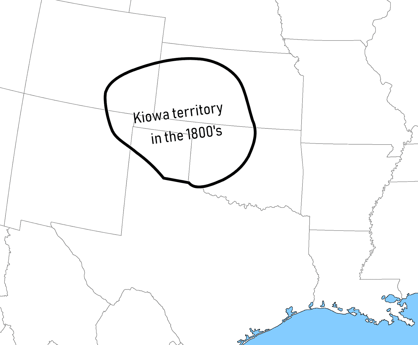
"Mooney (1907, Volume I:701) identifies
them [the Quiohuan] as Kiowas, an improbable speculation since the migration of
Kiowas into the Southern Plains did not occur until almost a century
later." (Newcomb 1993)
But the
truth is, it's more complicated than that.
Mooney's Calendar History is
not exactly an obscure text in this field: of
course the scholars who support the Quiohuan=Kiowa hypothesis are already
well aware of it. It's no secret to them
that the Kiowa formerly resided in the Northern Plains and the Kiowa
Mountains. They already know. I mean, look at that Newcomb quotation again:
who is it he says first identified the Quiohuan as the Kiowa? James
Mooney. Mooney may have been
wrong—about many things—but one thing you can't accuse him of is being unaware
of his own prior research.
So why do
scholars [most that I've seen, at any rate...] think that the Quiohuan were the Kiowa regardless? Well, to be honest I'm not entirely sure,
because I don't often see them explicitly argue the point: usually they just...
assert it, and move on. But I can
think of a few possible arguments one could make in defense of the Quiohuan=Kiowa
hypothesis.
Argument
#1: The Kiowa actually do originate in the Southern Plains,
despite all that stuff I wrote in Part 1.
There have been scholars who have questioned the accuracy of Mooney's
version of Kiowa protohistory. Robert
Lowie, an expert on the Crow Indians, specifically attacked the idea that the
Kiowa had once enjoyed a long and close relationship with the Crow:
"Since Mooney's thesis rests on
tradition, I ought to premise that while the briefest of stays with the Kiowa
sufficed to corroborate that the story is indeed part of their folklore, I
never once heard the Crow refer to the Kiowa in this connection, though I spent
seven or eight field sessions with them[...]
As for the Kiowa, they play so slight a figure in Crow thought that
though constant mention is made of the Hidatsa, the Dakota, the Cheyenne, the
Shoshone, and the Piegan, references to the Kiowa hardly ever occurred during
my visits." (Lowie 1953)
That is a
very interesting point—enough indeed to throw doubt on the accuracy of Mooney's
narrative—and I take it very seriously.
However, as Lowie also notes:
"Two questions must be distinguished
here—the [Kiowas'] earlier residence in the north and the specific affinity
with the Crow." (Lowie 1953)
Indeed.
"As for the former, what is involved is
of course not whether the ancestors of the Kiowa, along with other Indians,
came from the north ten thousand or five thousand years ago; the question is
whether in, say 1500 AD, they had their home in western Montana or, as has been
alleged, even in the neighborhood of the Sarsi; whether their occupancy of the
southern Plains falls into a very recent past.
On this point, I have no new observation to offer: I merely accept whole-heartedly
the suggestions made by Wissler and Kroeber, viz. that the tribe has been in
the region of the Canadian and Arkansas Rivers for a considerable period; that
their presence in the north 'may have been due to their periodic wanderings'
(Wissler); that after a temporary sojourn in the north they returned to their
southern habitat, 'legend retaining only the last of the events'
(Kroeber)." (Lowie 1953)
I like the
Mooney narrative because it's thorough and precise and it has a lot of
dates. But it's true that precision and
accuracy aren't the same thing, and I don't really have the scholarly toolset
to evaluate how reliable it is: all I can do is rely on what the experts
say. And while it's interesting to learn
that Clark Wissler and Alfred Kroeber both believed the Kiowas' northern
residence to be a temporary interruption of a more permanent residence in
the south... it is my distinct impression that modern experts have come to
agree with the Mooney narrative, at least in broad terms. Wissler and Kroeber were working during a
time when the Kiowas' northern origin was still an anomaly, when archaeologists
thought that the Fremont culture represented the early Apache. Scott Ortman makes (what seems to me, at least) a strong case for the Proto-Kiowa being in the Fremont area... or, if not
there, then at least at the northern end of a Kiowa-Tanoan dialect chain
extending north from the Colorado Plateau.
From that point, it's a matter of simple geometry to explain how they ended
up in Montana.
Argument
#2: The Kiowa were found in the east Texas region in 1687-1719, but they didn't live
there—they were just visiting ("visiting") from the north. There's a lot to be said for this
argument. It is true that the Kiowa in
historic days were incredibly mobile.
Mildred Mayhall says that Kiowa raiding parties could range as far and
wide as the Gulf of Mexico, the Gulf of California, and Canada. One raiding party allegedly went as far as Belize (British Honduras), which I find
a little incredible...
Furthermore,
it's a matter of record that Kiowas did occasionally wander as far south as
New Mexico in the early 18th century.
Spanish records from the 1730's onward report groups of "Caiguas" (etc.) pillaging
New Mexico settlements alongside Ute, Comanche, and Apache raiders. And David Brugge even found references to a Kiowa burial as early as 1727 in the church records of New Mexico (Brugge 1965). This fact alone would seem to belie the
notion that the Kiowas were too far away to have been the
"Quiohuans": if they could travel to New Mexico in the 1720's, what's
to stop them from traveling to the east end of Texas as well?
Two
responses to that. Firstly, the Kiowa as
they appear in the 18th century New Mexico records all share an important
dissimilarity to the Quiohuan, but I'll get back to that later. Secondly—and I could be wrong here—but it's
probably safe to assume that the Kiowas' globetrotting habits of later eras
were enabled by the acquisition of the horse.
Presumably they didn't walk to
Belize... and I suspect they didn't walk to Texas, either. Much has been written about how the
acquisition of the horse upturned Plains Indian culture in just about every
conceivable way. Mooney expressed it
rather picturesquely:
"It is unnecessary to dilate on the
revolution made in the life of the Indian by the possession of the horse. Without it he was a half-starved skulker in
the timber, creeping up on foot toward the unwary deer or building a brush
corral with infinite labor to surround a herd of antelope, and seldom venturing
more than a few days' journey from home.
With the horse he was transformed into the daring buffalo hunter, able
to procure in a single day enough food to supply his family for a year, leaving
him free then to sweep the plains with his war parties along a range of a
thousand miles." (Mooney 1898:161)
I know of no
references to the Quiohuan from before 1687 (see below). That seems rather early, to me, for a tribe
of southern Montana to have already acquired and mastered horsecraft. It's not impossible—the Rocky Mountain
Shoshone and Flatheads had horses by about 1700 (Hämäläinen 2003)—but I find it
unlikely. The Kiowa told James Mooney
that they didn't acquire horses until after they moved east of the Crow and
settled in the Black Hills, which Mooney estimated was after 1700. And, without the use of horses, I think it's
also unlikely that the Kiowas could have performed long-distance raids as far
south as Texas back in the 1680's. It's
also worth pointing out that the first
definite reference to the Kiowa in the New Mexico records postdates the last reference to the Quiohuan by nearly a
decade.
Argument
#3: It is true the Quiohuan were not in
east-central Texas in 1687-1719, nor even in Oklahoma, but then again no one
ever claimed they were. This argument
also has merit. Older maps appear to
show the "Quiohouhahan" etc. somewhere in Texas or maybe Oklahoma (or
maaaybe Arkansas), but the geometry
of those maps is very confused. For
example, they also tend to show the source of the Rio Grande as just a short
distance due west of Minnesota. I don't
know what Delisle's sources of information were for the upper course of the Red
River, Trinity River, etc... he may have just been guessing, for all I know.
A better way
to interpret the early maps is as just saying the Quiohuan were some undefined
distance inland. And the contemporary
documents which mention the Quiohuan may have only been reporting rumors of a
tribe located much farther into the interior than the authors themselves ever
ventured... maybe even as far as MT/WY/SD?
Is that possible?
Maybe. But I don't think it's probable. This is probably a good time to discuss the
documents themselves.
* * *
The first
time I'm aware of when "Quiohuan" (etc.) appears in writing is in the journal of Henri Joutel in 1687.
Joutel was among the Caddo at the time, staying in a Kadohadacho
("Cadodaquis") village in what is now the extreme northeast corner of
Texas:
"Now the chief often named the nations
for me, their enemies as well as their allies, and he named some I had heard
formerly from La Salle, and this pleased me.
I took the names of these nations and wrote them down so I could recall
them.
These tribes are their enemies:
Cannaha, Nasitti, Houaneiha, Catouinayos,
Souanetto, Quiouaha, Taneaho,
Canoatinno, Cantey, Caitsodammo, Caiasban, Tahiannihouq, Natsshostanno,
Cannahios, Hianogouy, Hiantatsi, Nadaho, Nadeicha, Chaye, Nadatcho, Nardichia,
Nacoho, Cadaquis, Nacassa, Tchanhe, Datcho, Aquis, Nahacassi
These tribes are their allies:
Cenis, Nassoni, Natsohos, Cadodaquis,
Natchittas, Nadaco, Nacodissy, Haychis, Sacahaye, Nondaco, Cahaynohoua, Tanico,
Cappa, Catcho, Daquio, Daquinatinno, Nadamin, Nouista, Douesdonqua, Dotchetonne,
Tanquinno, Cassia, Neihahat, Annaho, Enoqua, Choumay" (Joutel 1998[1684-7]:246)¹
The second
time is from a letter written in Spanish by Fray Francisco Casañas in
1691. Casañas had spent about a year
preaching the gospel among the Hasinai and Kadohadacho:
"The enemies of the Province of the
Áseney [Hasinai] are the following: Anao, Tanico, Quibaga, Canze, Áyx, Nauydix,
Nabiti, Nondacau, Quitxix, Zauanito, Tanquaay, Canabatinu, Quiguaya*, Diujuan, Sadammo." (Casañas 1927[1691])
(* - In one
of the printed editions, this name is spelled "Quiguayua".)
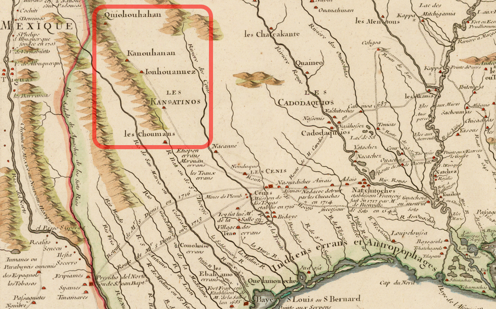
Then by 1716 (at least), the name begins to appear on French maps of North America. The mapmaker, Guillaume Delisle, had access to the journal
of Henri Joutel (Foster 1998:26), so his maps might not be an independent witness. However, as far as I know Delisle could not
have learned about the Yojuane ("Ionhouannez") from Joutel or anyone
else I'm aware of, so he may have had other sources of information.

The next
appearance is in 1717, in the "Declaration" of Louis Juchereau de St.
Denis. St. Denis was a French trader and
explorer who had spent time among the Natchitoches and the Hasinai. The document (written in Spanish, and by a
third party, which is why St. Denis is referred to as "he") reads:
"To the east of the Tejas [Hasinai] is
the Natchitoches nation on the Colorado [=Red] River, which empties into the
Mississippi. Those which are to the
north, northwest, and west of the Asinais are the nation Yojuan, the Tancahoe, the Quihuugan, the Guanetjaa, the
Nodacao, the Quitzais, Saccahe, Nauittij, Canohatinoo, Conux, Tahoangaraa,
Cahineo, and there are others whose names he does not remember. He [St. Denis] knows of them from what he has
heard the Tejas say and by reports which they themselves have heard. These nations do not have villages nor fixed
abodes because of fear of the Apaches." (St. Denis 1923[1717])
The next is
from 1719, from the journal of Bénard de La Harpe's exploration of the Arkansas
River. La Harpe had sent his aide, a M. Du
Rivage, on a reconnoitering expedition up the Red River:
"...he reported to me that at seventy
leagues by land to the westward and from the west a quarter northwest, he had
encountered part of the nomadic tribes, which are Quidehais, Naouydiches,
Joyvan, Huanchané, Huané, Tancaoye, by whom he had been very well received.
[...] These nations are allied with that of the Quiohuan, situated at two leagues from the Red River, on the
left, in going up to the environs of the place where M. Du Rivage had found
these nomadic nations." (La Harpe 1958[1718-20])
Daniel
Prikryl (2001)
locates Du Rivage's encounter in the area around Lake Texoma, Texas.
The next
time the name appears is in an anonymous document entitled Mémoire sur les Natchitoches (in Margry V6:228). The text is undated, but according to
Gunnerson & Gunnerson (1971) was written shortly after 1718:
"The nations which are near [the Red
River], or which are established on its course, from its mouth to the places
known to us, are the Aouayeilles, the Innatchas, the Quiouahans, the Touacanna or Paniouassas; these are near the
River of the Otouys." (in Margry 1886 (Vol 6):228) [via Google Translate]
The last
time the name appears is in a work by Baudry des Lozières: Voyage a la Louisiane, et sur le Continent
de l'Amérique Septentrionale, written from 1794 to 1798. This one can probably be discounted; I
explain why in footnote 2.
Those are
all the examples I could find of the Quiohuan being named in the historical
documents. There may be more
examples—real-life historians who work with physical manuscripts might be able
to find some—but for right now, that's all I got.
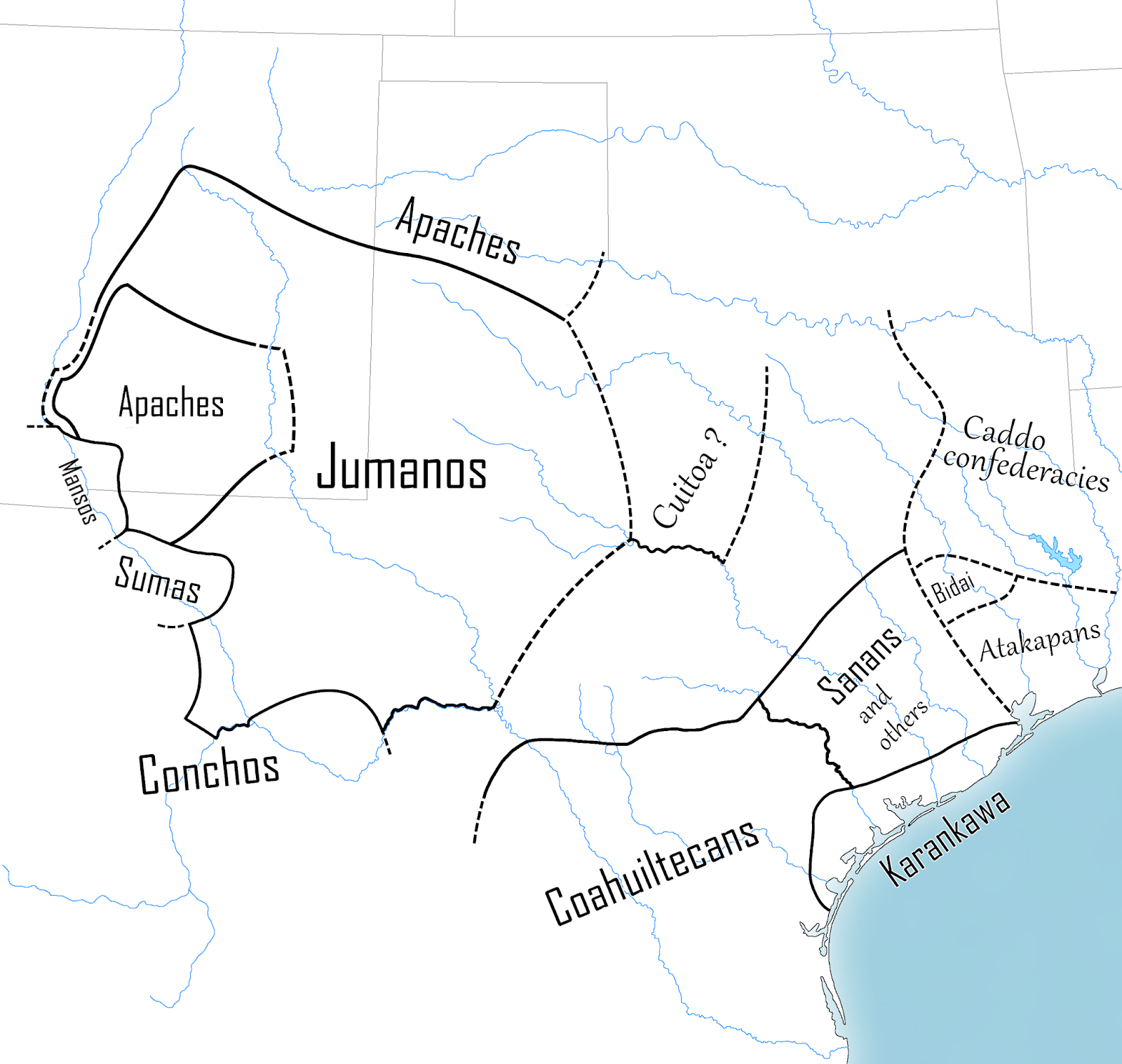
These
documents all name the Quiohuan as either enemies or neighbors of the Caddo, or
as allies or neighbors of the Wichita.
The Caddo and Wichita often fought each other, so the politics are
consistent, one anomaly being the "Naouydiches" (etc.) who are called by a Caddo name (Nawidish - "Salt Place") even by Du Rivage's informants who, presumably, spoke Wichita. Among the other tribes named that can be
identified, most are either Caddo groups or groups reasonably close to the
Caddo, such as Natchezan or Wichitan tribes.
The most distant outliers (again: that can be identified) are the
Kansa (eastern Kansas) and the Tonkawa (northern Oklahoma, at most).
Any tribe
from the north of Kansas—much less the plains west of the Black Hills—would be
a very distant, oddball outlier on these lists.
That makes it unlikely that the "Quiohuan" were a tribe
situated that far north, who were only known about second-hand. In combination with the La Harpe account and
the anonymous Mémoire³—which locate
them in north-central Texas and northwest Louisiana—it also makes it unlikely
that the Quiohuan were a northern tribe who only made seasonal raiding
appearances in the south. That eliminates Arguments #2 and #3. Since almost all the other tribes named in
the primary sources are southern tribes, it's reasonable to assume that the
Quiohuan were a southern tribe as well.
Which means that they were not Kiowa.
However,
that's not even my main reason for doubting the Quiohuan=Kiowa hypothesis. My main reason is the simple observation that
"Kiowa" and "Quiohuan" don't even look like they are the
same name... not after you take English's unusual vowel spelling into
account. The name "Kiowa" is pronounced in English more or less like [kaiowa] or [kaiawa].⁴
The various times that the Kiowa are mentioned in Spanish colonial documents from New Mexico:
Cahiaguas,
Cahiguas, Caihuas, Cargua [supposedly a
misprint for *Caigua], Cayouas, Caigua, Caygua, Cahihua, Caiua, Cayba,
Caiba, Cayga
[source: Mooney (1898) and Brugge
(1965)]
...all seem
to represent a similar pronunciation: something like [kaiwa].⁵ The English and Spanish forms are relatively
straightforward renditions of the name as found in various Native American
languages:
Káhiwaʔ (Caddo),
Káhiwaʔa (Wichita), Kahíwa (Kitsai), Káʔiwa (Pawnee), KaʔíwA (Arikara),
Kaiwa~Kaiwɨ (Comanche), Kkáðowa (Osage), Kkáʔiwa (Kansa and Ponca), "Gaiwa" (Omaha), Kaíwa (Oto), Kaiwah (Shoshone), Gáiwa
(Towa)
(other languages use names that
are completely unrelated)
[source: Handbook of North American
Indians Volume 13(2)]
These are
all pretty consistent—usually [kaiwa], [kahiwa], or [kaʔiwa]—making the
question of which language English and Spanish borrowed the name from
irrelevant.
Now, on the
other hand, the various spellings of Quiohuan:
in
French:
Quiouaha,
Quiohouhahan, Quiohouan, Quichuan [for
*Quiohuan], Quiohuan, Quiouahans
in
Spanish:
Quiguaya
[or maybe *Quiguayua], Quihuugan
...all look
like attempts at spelling something like [kiwa] or [kiowa] (or possibly [kiwaą]
or [kiowaą]). I think this is a different name. There appear to be two
separate names here: one, a kai-
name, definitely referring to the Kiowa each time it appears; and another, a kio- name, which only ever refers to a
tribe in/near east Texas... in what would be an unusual place and time to find the Kiowas. The visual similarity between the names
"Quiohuan" and "Kiowa" is the only reason anyone believes
in a Kiowa-Quiohuan connection in the first place (and not in, say, a
Kiowa-Canohatino connection). But if the
two names are not in fact the same,
then that leaves no more reason to believe that the Quiohuan were the Kiowa.
Is it wise
to be this literal in interpreting colonial-era spellings of Indian names
phonetically? Individually: no. Europeans were barely consistent in spelling
their own languages in the 17th-19th centuries, let alone the languages of
North America with their glottal stops and lateral fricatives and so on. Individually: it's more likely that a
European, upon hearing a word in an Indian language, would inadvertently
distort it in some way (either by mishearing it, misremembering it, or just
being sloppy in writing it down).
But we're
not dealing with an individual
attestation of a name—we're dealing with
about twenty. It's one thing to say that
the name was distorted... it's another to say that the name was distorted
multiple times in exactly the same way
each time. Furthermore, the
difference in orthography corresponds exactly to the difference in geography:
all of the kio- names come from the
region around east Texas, and all of the kai-
names come from outside it. Mathematically,
it's highly unlikely this would happen by chance. There are only three ways one could wave away
this anomaly.
One way is
to say that the name [≈kaiwa] wasn't distorted numerous times into [≈kiowa]—rather,
it only happened once. Like a genetic
mutation that only has to happen one time and then gets inherited by all of the organism's descendants, maybe there was one initial French writer (Joutel in this case) who rendered
the name as "Quiouaha", and then all later writers were just copying
him. On its own merits, this explanation
seems unlikely. Delisle and Beaurain
were copying other documents, yes, but I see no reason to conclude that La
Harpe, Casañas, and St. Denis were all copying Joutel (or each other)—they seem
to all be separate and independent witnesses.
Another
possible explanation is that the various spellings of "Quiohuan" are
all based on an intermediate Indian language, one in which the original [≈kaiwa]
had become [≈kiowa]. Like the previous
explanation, this removes the statistical unlikelihood of numerous identical
mutations by positing only one mutation instead. Unfortunately, however, it's an appeal to
nonexistent evidence: no such intermediary form is attested in any Indian
language that could have been the source of the kio- spellings. Joutel explicitly
says he heard the name from a (Caddo-speaking) Kadohadacho chief, and it's hard
to believe any of the other authors got their versions via any language other
than Caddo or Wichita. But the name for
the Kiowa in the Caddo and Wichita languages is Káhiwaʔ and Káhiwaʔa,
respectively. Not **Kihowaʔ or whatever you might want for this explanation to work.
Another way
to wave away the anomaly, is to say that the "Quio-" spelling or the kio- pronunciation is just a French idiosyncrasy
that arises for some reason. This
explanation can be easily dismissed on both sides. For one, "Quiguaya" and
"Quihuugan" both look to be kio-
names, yet they both come from Spanish
documents. For another, the first time
that the Kiowa are unambiguously named (i.e. in their historically attested
location) in a French document, that document uses a kai- spelling: the document in question is by Perrin du Lac in
1802, the location is western South Dakota, and the spelling is
"Cayoavvas" (Mayhall 1971:23).
This proves that Frenchmen were entirely capable of accurately writing
[≈kaiwa] if they wanted to. The fact
that both they and the Spaniards only
wrote [≈kiowa] when referring to a tribe in/near eastern Texas, and never wrote it anywhere else... means
that the tribe in/near eastern Texas was not the Kiowa. The
Quiohuan were not the Kiowa.
I'm pretty
sure I am not being circular in my argument.
I didn't pre-select all of the kio-
names because they were kio- names and then say: Hey! Look!
They're all kio- names! The chronological and geographical separation
of the Quiohuan from the Kiowa is real. So
is the consistent way in which one group is called by kio- names, and the other by kai-
names. There is no overlap, and no
exception to the pattern, and it cannot be explained away as happenstance. The evidence points to the existence of two
different, unrelated Native American tribes: the Kiowa and the Quiohuan.
 |
Locations associated with the Kiowa and Quiohuan. K1: Kiowa homeland (pre-1700). K2: Montana plains (1700-1775). K3: Black Hills (pre-1775). K4: Location of Cheyenne, who shared territory with the "Cayoavvas" according to Perrin du Lac (1802). K5: North Fork of the Platte River, location of the "Kiawas" according to William Clark (1804). K6: Arkansas River, location of Kiowa-Comanche truce (1806). Q1: Kadohadacho village visited by Joutel (1687). Q2: Hasinai villages visited by Casañas and St. Denis (1691-1717). Q3: Natchitoches village visited by St. Denis, also the location of the "Quiouahans" according to the anonymous Mémoire (1717-1718). Q4: Location of the "Quiohuan" reported by M. du Rivage (1719). C: New Mexico, where Spanish documents record the presence of "Caiguas" (1727 and after). P: Possible location of the "Pioya" or "Piwassa" encountered by La Vérendrye (1742).
|
I know of
only one putative counterexample to the pattern that the Kiowa are never unambiguously called
by a kio- name. I say
"putative" because in fact it is not actually a counterexample, as I
will explain:
In 1742, François
de La Vérendrye departed from the Mandan villages in North Dakota and headed
southwest, trying to find any Indian group who might direct him to the Pacific
Ocean. He never reached the Pacific, and
had to turn back after coming near to an unidentified mountain range which
people have since speculated may have been the Black Hills, the Bighorn
Mountains, or the Wind River Range. All
three possibilites would place La Vérendrye's itinerary in or near Kiowa territory.
La
Vérendrye's account mentions several Indian groups that his expedition
encountered, some of which may have been tribes, others bands within a single tribe. The tribes or bands are identified using
names that are descriptive but not very helpful: the Bow People, the Beautiful
Men, the Little Cherry People, etc.
However, one group is named phonetically rather than in translation: the
Pioya. It has been said that these "Pioya"
were the Kiowa, and that the name results from somebody miscopying an earlier
manuscript in which the name was spelled "Kioya".
Unfortunately,
this theory is rendered unlikely by the existence of a summary of La
Vérendrye's expedition written by Louis-Antoine de Bougainville in 1757. Bougainville apparently, somehow, had more
information on the Indian tribes encountered by the expedition than La
Vérendrye gives in his own account (perhaps he had an inside source), and he gives for each tribe their Cree or Ojibwe appellation in addition to the French.
This makes it easier for modern linguists to identify them.
As for the
Pioya, Bougainville calls them the "Piwassa" and says that this name
means "Grands-Parleur" or Great Talkers (Parks 2001). Unfortunately this still doesn't tell us who
the Pioya were, since apparently neither Pioya
nor Piwassa are recognizable words in
any Native American language. But if the two
versions of the name are at all related, then it means that "Pioya" is probably close to the original form—in other words, it is not a misprint for
"Kioya". Also of note: the
name "Kiowa" does not mean "Great Talkers"—supposedly, it
means "Elks".
That doesn't
prove that the Pioya were not the Kiowa, of course. But it does prove that at least the name
"Pioya" has nothing to do with the name "Kiowa". And that means that what I said before still stands: that
the Kiowa are never anywhere referred to using a kio- name.
So in
summary, I do not think that the Quiohuan were the same people as the
Kiowa. I do not know who the Quiohuan were—some tribe of eastern
Texas or southern Oklahoma or maybe western Louisiana or Arkansas... often
enemies of the Caddo, especially the Hasinai—but they were not the Kiowa. Maybe they were a small tribe who (like so many
in the 18th century) merged with others to form a new corporate tribal entity,
losing their previous identity in the process. Maybe the name "Quiohuan" is
synonymous with some other Native American group that usually goes by a
different name. Maybe they were all
killed...
... Or maybe they were the Kiowa. Shit, I dunno.
... Or maybe they were the Kiowa. Shit, I dunno.
( Postscript:
One group who I have not mentioned is the "Marhout" or "Manrhout",
a tribe who according to La Salle lived south of the Wichitas in 1682-3 (Wedel 1973;
Hickerson 1996). La Salle mentions the Manrhout alongside another tribe called the "Gatacka", a name that usually refers to
the Kiowa-Apaches (from Pawnee Katahkaaʾ),
and it is for this reason people often say that the Manrhout were the
Kiowas. The reason I haven't mentioned them before now
is because I see no good reason to think that the Manrhout were the Kiowas, or
anyone else in particular. The name
"Manrhout" is not attested anywhere else except in sources based on
La Salle. Furthermore, the word katahkaaʾ in Pawnee refers not only to
the Kiowa-Apaches but also to "any tribe west of the Pawnees" (Parks & Pratt
2008), so it's not as useful as some would have you think. )
Notes
1.
Joutel also mentions a "Quouan" tribe earlier in his
account. I don't know if that is related—I
haven't seen anyone else mention them when discussing the Kiowa or Quiohuan.
2. The
name "Les quiohohouans" appears in Voyage a la Louisiane, et sur le Continent de l'Amérique Septentrionale
by Baudry des Lozières (written 1794-8), evidently the last time any variant of
the name Quiohuan appears in a historical document. The name appears on a list of apparently all
the Indian tribes of Spanish Louisiana that B. de Lozières was aware of. Other than that, nothing is said about
them. Since the list also includes the
names of several other obscure tribes which were probably gone by 1794, I
assume that Lozières was copying numerous older sources, and that this is also
where he heard about the "Quiohohouans".
3. The
Mémoire seems a little odd to me
(maybe blame Google Translate). Sometimes
its "Rivière Rouge" seems to be referring to the Red River, sometimes
to the Arkansas River. The "Innatchas"
are the Natchez, the "Aouayeilles" are the Avoyel (a Natchezan
tribe), and the "Touacanna or Paniouassas" are the Tawakoni Wichitas. The "River of the Otouys" probably
refers to the Osotouy, a Quapaw group who lived near the confluence of the
Arkansas and Mississippi rivers, and not to the Otoes who lived way further
north.
4. I'm
only considering the modern, standard pronunciation of English
"Kiowa". English spelling is
such a trainwreck that any attempt to interpret the intended pronunciations of
historical English spellings would just muddy the data.
5. Not to go into the niceties of Spanish phonology in the main body text... Historically the phoneme /w/ in Native languages was often rendered <u>, <hu>, or <gu> by Spanish writers. Spanish itself has no such phoneme, so for monolingual speakers this would probably be more like [kaiɣua] or [kaixua], which are close enough. Meanwhile, modern
Spanish has apparently borrowed "Kiowa" from English in both spelling and pronunciation, at least going off of Spanish Wikipedia and this video.
Sources
(primary):
[anonymous],
Mémoire sur les Natchitoches [undated,
probably written shortly after 1718].
Published in: Pierre Margry (ed.), Découvertes
et Établissements des Français dans l'Ouest et dans le Sud de l'Amérique
Septentrionale, Vol 6:228.1886.
Louis-Narcisse
Baudry des Lozières, Voyage a la
Louisiane, et sur le Continent de l'Amérique Septentrionale, fait dans les
années 1794 à 1798. 1802.
Jean
Chevalier de Beaurain, Journal Historique
de l'Établissement des Français a la Louisiane. 1831. (Allegedly a rewrite of La Harpe, Relation du Voyage.)
Francisco
Casañas de Jesús María, Letter and Report
of Fray Francisco Casañas de Jesus Maria to the Viceroy of Mexico, Dated August
15, 1691 [1691]. Spanish text in:
John Swanton, Source Material on the
History and Ethnology of the Caddo Indians. 1942. English translation in: Descriptions of the Tejas or Asinai Indians, 1691-1722, tr. Mattie
Austin Hatcher. 1927.
William
Clark, "Fort Mandan Miscellany" [1804-5]. Accessible online.
Jean-Baptiste
Bénard de La Harpe, Relation du Voyage de
Bénard de La Harpe [1718-20]. French
text in: Pierre Margry ed., Découvertes
et Établissements des Français dans l'Ouest et dans le Sud de l'Amérique
Septentrionale, Vol 6:243. 1886.
English translation in: Account of
the Journey of Bénard de la Harpe: Discovery Made by Him of Several Nations
Situated in the West, tr. Ralph A. Smith. 1958.
François de
La Vérendrye, Journal of the Voyage Made
by Chevalier de la Verendrye, with One of His Brothers, in Search of the
Western Sea Addressed to the Marquis de Beauharnois [1742-3], tr. Anne H.
Blegen. 1925.
Henri
Joutel, The La Salle Expedition to Texas:
The Journal of Henri Joutel 1684-1687 [1684-7], tr. Johanna S. Warren, ed.
& commentary William C. Foster. 1998.
Louis
Juchereau de St. Denis, St. Denis's
Declaration Concerning Texas in 1717 [1717], tr. Charmion Clair Shelby. 1923.
Sources
(secondary):
David M.
Brugge, Some Plains Indians in the Church
Records of New Mexico. 1965.
William C.
Foster, Introduction and commentary in The
La Salle Expedition to Texas: The Journal of Henri Joutel 1684-1687. 1988.
Sally T.
Greiser, "Late Prehistoric Cultures on the Montana Plains", in Karl
H. Schlesier ed. Plains Indians: A.D.
500-1500: The Archaeological Past of Historic Groups. 1994.
James H.
Gunnerson & Dolores A. Gunnerson, "Apachean Culture: A Study in Unity
and Diversity", in Keith H. Basso & Morris E. Opler ed. Apachean Culture History and Ethnology. 1971.
Pekka
Hämäläinen, The Rise and Fall of Plains
Indian Horse Cultures. 2003.
Kenneth E.
Hendrickson, Jr., "Brazos River”, in the Handbook of Texas Online, published online: 2010.
Nancy P.
Hickerson, "Ethnogenesis in the South Plains: Jumano to Kiowa?", in
Johnathan D. Hill ed. History, Power, and
Identity: Ethnogenesis in the Americas, 1492-1992. 1996.
Elizabeth
A. H. John, Storms Brewed in Other Men's
Worlds: The Confrontation of Indians, Spanish, and French in the Southwest,
1540-1795. 1975.
—, An Earlier Chapter of Kiowa History. 1985.
Jerrold E.
Levy, "Kiowa". In Handbook
of North American Indians Vol 13(2). 2001.
Robert H.
Lowie, Alleged Kiowa-Crow Affinities. 1953.
Mildred P.
Mayhall, The Kiowas. 1971.
William C.
Meadows, New Data on Kiowa Protohistoric
Origins. 2016.
James
Mooney, Calendar History of the Kiowa
Indians. 1898.
John H.
Moore, Margot P. Liberty, A. Terry Straus, "Cheyenne". In Handbook of North American Indians Vol
13(2). 2001.
William W.
Newcomb, Jr., Historic Indians of Central
Texas. 1993.
Morris E.
Opler, "The Apachean Culture Pattern and Its Origins". In Handbook of North American Indians Vol
10. 1982.
Scott G.
Ortman, Winds from the North: Tewa
Origins and Historical Anthropology. 2012.
Scott G.
Ortman & Lynda D. McNeil, The Kiowa
Odyssey: historical relationships among Pueblo, Fremont, and Northwest Plains
peoples. 2017.
Douglas R.
Parks, "Enigmatic Groups". In Handbook of North American Indians Vol 13(2). 2001.
Douglas R.
Parks & Lula Nora Pratt, A Dictionary
of Skiri Pawnee. 2008.
Daniel J.
Prikryl, Fiction and Fact about the
Titskanwatits, or Tonkawa, of East Central Texas. 2001.
David
Leedom Shaul, A Prehistory of Western
North America. 2014.
Mildred
Mott Wedel, The Identity of La Salle's
Pana Slave. 1973.