[This is part 1 of a 2-part series of posts about
the identity of the Quiohuan Indians. Click here for part 2.]
In a previous post on this blog, I examined the question of who the aboriginal inhabitants of
Central Texas were at the beginning of the frontier era (or approximately 1600
A.D.). In it I came to the conclusion
that, in the absence of better sources, the best I can do is rely on the
account of Alonso de Posada, who reported that in the mid-1600's a tribe lived
in western Central Texas (henceforth "WCT") whom he called the
Cuitoa. I then updated my
work-in-progress map as follows:
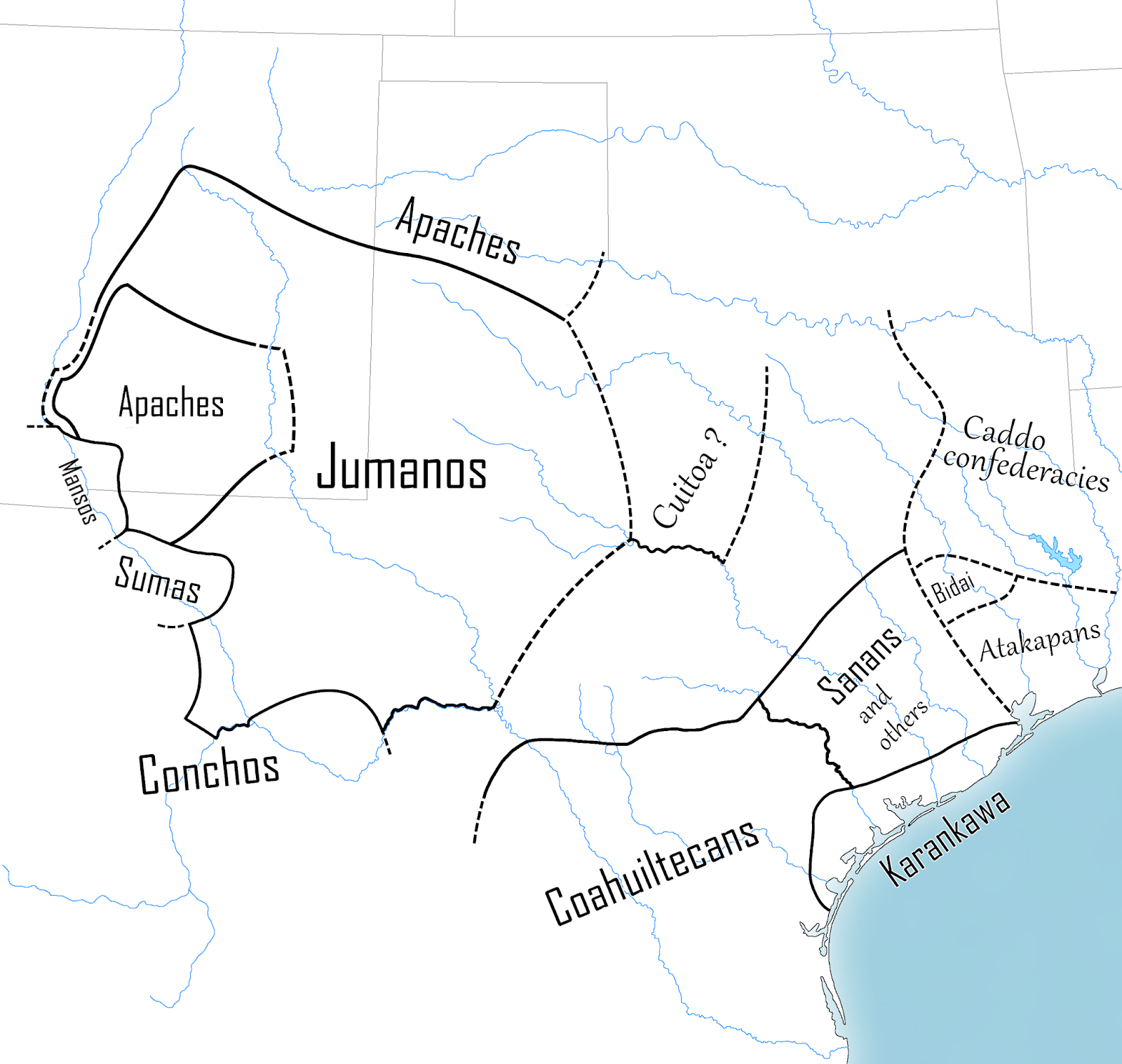 |
| Texas ca. 1600 |
That still
leaves two gaps: one mostly covering the Edwards Plateau, and the other
covering eastern Central Texas (henceforth "ECT"). Regarding ECT, I further concluded the
Tonkawa—who lived in ECT in later centuries—can be ruled out, as in 1600 they
lived much farther to the north. As a
note on that point: I have since learned new information which has forced me to
change my conclusions a bit. It now
seems that the Tonkawa were not in central Kansas, as I wrote, but were
actually in northern Oklahoma. Either
way, they were not in Central Texas.
However, the
question remains: who were the
peoples of ECT in 1600? That question
will... not be answered in this post, nor in Part 2. The purpose of this post, rather, is to discuss
which tribe was not in ECT in
1600. (Spoilers: it's the Kiowa.)
The literary
sources for ECT are various and confusing for a layman like myself—especially
when they're in untranslated French, a language that I can't read. They also tend to be late (ca. 1680's onward),
at least when compared to the Spanish documents that describe WCT. So instead of discussing those documents
right now, just for the moment let's look at some early maps of North America
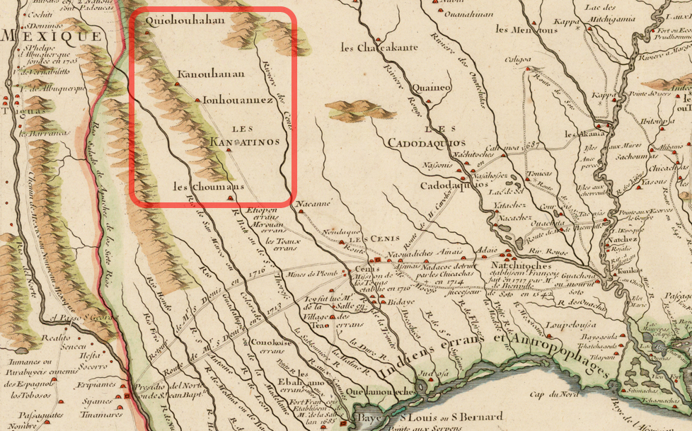
and see what they have to say. Here is
one from 1703 (I've outlined the ECT area in red):

Here's another from 1718 (which is a more
nicely-drawn version of an earlier map from 1716):
These maps were
both created by the famous cartographer Guillaume Delisle, patron saint of
North American mapmakers. I happen also
have another of his maps in hardcopy, this one from 1722, and I might as well
show it as well:

It's
difficult to interpret these maps, created as they were long ago, from very
limited data, with contradictions regarding the locations of rivers and of
Indian tribes, all of which are given under obsolete names. However, the first two maps contain a similar
cluster of names for the tribes dwelling somewhere along (or above or
north/northeast of) the "Rivière
Maligne" and west (or above) the "Rivière des Cenis". The
Cenis is the modern Trinity River,
and the Maligne may be either the
Brazos or the Colorado (cf. Hendrickson 2010, Foster 1998:33). In no particular order, the names of these
tribes are:
Canoatinno/Kanoatino[s],
Chouman[s], Cannesi, Quichesse, Canoüaouana/Kanouhanan, Quiohouhahan/Quiohouan,
Iouhouhouane/Ionhouannez
I will have
much more to say about these names in the future (some are easier to deal with
than others), but for now I only want to focus on one: Quiohouhahan/Quiohouan. Variants of this name appear in several
French documents from the colonial period (e.g. "Quiouaha" in the
journal of Henri Joutel), and it appears to be the same as the
"Quiguaya" mentioned in a Spanish document from 1691 (Casañas
1941[1691], Joutel 1998[1684-7]:246).
It is also
the same as another name I've discussed previously on this blog:
"Quichuan", a tribe who Sieur du Rivage, Benard de la Harpe's aid,
located just south of the Red River in 1719.
"Quichuan" is how this name is spelled in Ralph Smith's
English translation of La Harpe's journal, and in the French version found in
volume 6 of Pierre Margry's Découvertes
et Établissements des Français dans l'Ouest et dans le Sud de l'Amérique Septentrionale. However, in another account of La Harpe's
voyage—allegedly edited (or written?) by Jean Chevalier de Beaurain and
published in 1831—the name is spelled like "Quiohuan".
Interestingly,
I was also able to find another Guillaume Delisle map—this time from 1717—which
uses the <c> spelling, so the confusion over how to spell this name is
quite old:

This I think
proves that the the names "Quichuan" and "Quiohouan"(etc.)
are supposed to be the same. It also shows
that there was confusion over whether to spell it with <c> or <o>
already by the early 1700's. The weight
of evidence now seems to strongly come down in favor of the <o>
spelling. In a previous post, I
speculated that La Harpe's "Quichuan" might be the same as the Cuitoa
and/or the Quitaca: it now seems that I was wrong.
Now, having
just said that I was previously wrong about the identity of the Quiohuan, I am
going to stick my neck out and risk being wrong again, because I've decided
that I disagree with the scholarly consensus on this. Almost every author who I have seen mention
the Quiohuan has identified them as the Kiowa.
At first glance, this identification seems pretty obvious. For one, the two names are already almost
identical, modulo French spelling. For
another, the recorded location of the Quiohuan (somewhere in
northish-centralish Texas roundabout the vicinity of the Red River) is reasonably
close to the Kiowas' territory later, in the 1800's:
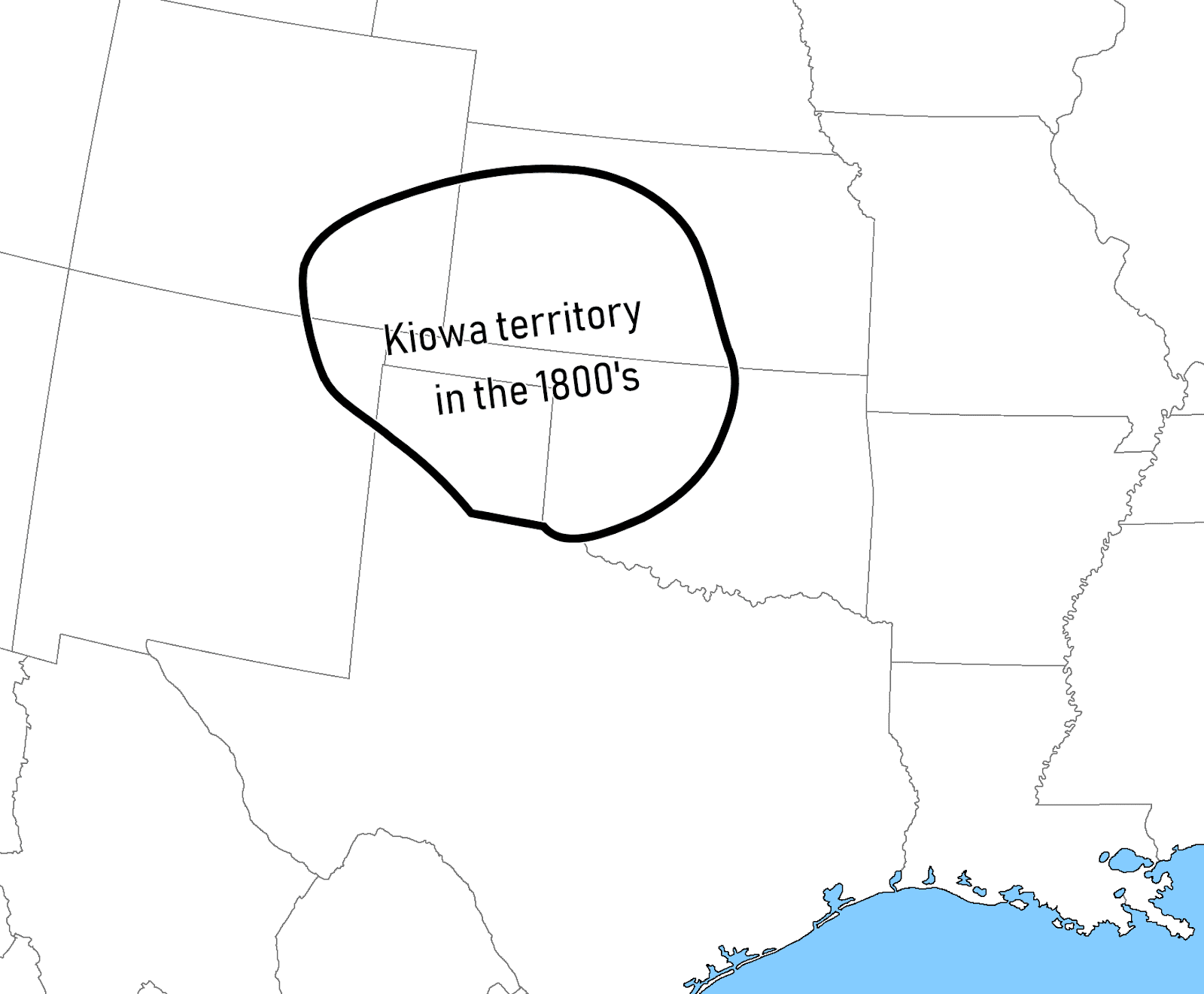 |
| Based on map in Handbook of North American Indians. Note that the Kiowa territory as shown here severely overlapped with that of their allies the Comanche. |
If this
theory is true, then that would make the Kiowa one of the tribes in ECT during
the late-1600's and perhaps earlier, meaning that I could write
"Kiowa" into that blank space on that map of mine. However,
I believe that the identification of the Quiohuan as the Kiowa is wrong. Explaining why I think it's wrong, why the
experts think it's right regardless, and why I still think they're wrong
double-regardless, will be the topic of Part 2.
Before I get to that, however, I need to lay out some preliminaries—I
need to discuss the origins of the Kiowa.
A good way
to figure out a people's origin is to look at their language. The language that the Kiowas speak belongs to
the Kiowa-Tanoan language family, meaning that it (/they) shares a common
ancestry with the Tanoan languages (/peoples) of the Pueblo region, in northern
New Mexico.
 |
| The Pueblo Region ca. 1600 (from John (1975)). I've color-coded the settlements by language group: cyan=Tanoan, scarlet=Keresan, purple=Zuni, orange=Hopi (Uto-Aztecan), and yellow=Unknown. |
According to
an analysis of the names for various flora and fauna as reconstructed in the
Proto-Kiowa-Tanoan language, the common ancestors of the Kiowas and Tanoans
lived reasonably close to the Pueblo region: meaning that the Kiowas are the
ones who moved out and the Tanoans are the ones who (mostly) stayed put. One might conclude, therefore, that the
Kiowas reached their historic location via a quick jaunt to the east:

This, as it
turns out, is not the case. According to
tribal tradition, as documented by James Mooney in 1898, the ancestral Kiowa homeland lay far to the north, in the
mountain valleys of southwestern Montana near the headwaters of the Missouri
and Yellowstone rivers, whence they subsequently moved eastward and into the
Black Hills. Further testimony from the
Arapaho, Crow, and Lakota tribes confirms that the Kiowas formerly occupied the
region between the Yellowstone River and the Black Hills. Mooney estimated this residence as lasting roughly
from just-before-1700 to just-after-1775.
So, the
trajectory of the Kiowas' from the Proto-Kiowa-Tanoan homeland actually looks
like this:

So how did
they get way up there, and how do we know it?
In order to be any more specific, I have to talk about archaeology,
which is something I never like doing because I don't really understand
archaeology [and because no 2 authors can ever
agree on dates...]. But
I'll do my best. My chief sources of
information here are the works of Scott G. Ortman (2012 & 2017).
With that
said, here is—as far as I can manage—a brief history of the Kiowa to 1806:
* * *
If there
ever was a "Golden Age" of Native American civilization north of
Mexico, I suppose it would be from ≈1000 to ≈1300 A.D. It was during this period that, almost
simultaneously, you have both the Anasazi cliff-dwelling cultures in the
Southwest and the moundbuilding cultures of Cahokia-and-environs in the eastern
woodland. Both of these cultures are
prominent enough that they get mentioned pretty often in mainstream
publications—you've probably heard of them.
To some extent this Golden Age existed on the Plains as well, since this
is also when you get the (Panian-speaking) Central Plains Village culture in
Nebraska-Kansas.
 |
| Archaeological cultures of the Southwest during the Golden Age. (I forgot the source for this.) |
This Golden
Age came to an end during the 14th century: ca. 1300 for the Anasazi, and a
little later for the Moundbuilders (note that this is over a century before
Columbus was born). I don't think people
entirely know what caused the collapse. For
Cahokia, I've seen it said that they succumbed to political instabilities
inherent to the paramount chiefdom-style of government. The collapse of the Anasazi has been blamed
on foreign invasion, drought, overexploitation of natural resources, and
political turmoil—one expert I contacted compared their situation to that of modern-day
Syria.
By the way, I
can't mention the Anasazi without mentioning that they were something of a meme
back in the 1990's. For some reason, and
I don't know why, people kept wanting to find something supernatural involved
in their disappearance. There was an
episode of The X-Files about the Anasazi, as well as an episode of In Search Of
hosted by Leonard Nimoy. I also remember
an episode of The Real Adventures of Johnny Quest where it was implied that the
Anasazi had been abducted by aliens.

It's
generally assumed that the Anasazi were the ancestors of the modern day Pueblo
peoples: the Tanoans, Keresans, Hopi, and Zuñi... though there may have been
other groups as well that have since vanished to history (it's been suggested
that the Piro were one such group, but cooler heads seem to think that they
were Tanoan). These ancestral Puebloans
were once more spread out, but after the Anasazi collapse they concentrated
into the Pueblo region.
As I said,
the Kiowa are related to the Tanoans, and an analysis of the reconstructed
Proto-Kiowa-Tanoan lexicon points to the Pueblo region as their ancestral
homeland—actually a bit to the north of the Pueblo region proper, in the zone between
the San Juan and Colorado Rivers (Ortman 2012).
But the Kiowa were never in the Pueblo region in historic times, meaning
that when the Tanoans moved south following the Anasazi collapse, the Kiowa did
not accompany them. So where were they,
and where did they go?
According to
Scott Ortman, the ancestors of the Kiowa were not among of the classic-period
Anasazi people. Rather, they were in the
Fremont region in Utah, north of the Anasazi (see map). Ortman's argument has to do with dates, so
let's talk dates. Here is a rough
chronology of archaeological phases in the Anasazi region, at least according to some
sources:
Basketmaker II: ≈ 1 – 500 A.D.
Basketmaker III: ≈ 500 – 700 A.D.
Pueblo I: ≈
700 – 900 A.D.
Pueblo II: ≈
900 – 1100 A.D.
Pueblo III: ≈
1100 – 1300 A.D.
Pueblo IV: ≈
1300 – 1540 A.D.
[Prior to Basketmaker II is the Archaic
period. There apparently isn't a
"Basketmaker I".]
At what
point in this sequence did the Kiowa first separate from the Tanoans? Estimates using glottochronology usually date
the Kiowa↔Tanoan split to several millennia ago: Davis estimated the it at ≈2250
B.C.; Hale and Harris revised this to ≈1000 B.C. (qtd. in Shaul 2014:104). But glottochronology is messy, and these
numbers apparently seem off according to the experts. For example, Davis estimated that nearly
2,000 years separated the Kiowa↔Tanoan split from the first internal split of
Tanoan (Towa↔Tiwa-Tewa), but Hale, Harris, and Laurel Watkins all write that
the Kiowa language does not seem that much more different from the Tanoan
languages, than the Tanoan languages are from each other, for the Kiowa
departure to have predated the internal Tanoan split by very much time, if at
all.
Scott
Ortman, more-or-less throwing glottochronology out the window, recalculated the
timeline of the Kiowa-Tanoan family using the apparently more reliable Wörter-und-Sachen method
("Words-and-Things"). He
describes the method thus:
"The principle behind this method is that
when one can reconstruct a word for a cultural item in a protolanguage, one can
also assume that the associated item was known to the speakers of that
language. If it is also possible to date
the initial appearance of the item using archaeological evidence, one can argue
that the protolanguage diversified after the introduction of that item. Terms for cultigens and material culture are
most useful for this type of analysis, and together provide one of the
strongest and most direct links between archeology and language." (2012:162)
So, for
example, Proto-Tanoan can be reconstructed as having words for the
bow-and-arrow and various appurtenances of advanced maize agriculture, but
Proto-Kiowa-Tanoan can only be reconstructed as having words for simpler maize
agriculture, with no bow-and-arrow. I
believe this same method has also been used to estimate when
Proto-Indo-European was spoken, based on the various vocabulary for chariot
technology that can and can't be reconstructed in PIE.
Using this
method, Ortman calculates that the Proto-Kiowa-Tanoans were a people of the Eastern
Basketmaker II phase, and the Proto-Tanoans were of the Eastern Basketmaker III
phase. He dates the transition between
Basketmaker II and III to around 450 A.D.:
 |
| The Kiowa-Tanoan language family, with forking dates estimated using the Wörter-und-Sachen method. Based on Ortman (2012). |
So the
ancestors of the Kiowas broke off from their Tanoan kinsmen at some point
before 450. This is coincident with
several lines of evidence that show a migration of Eastern Basketmaker II
people from the Anasazi region into the Fremont during the first half-millennium
A.D.:
"Many lines of evidence support this
association. First, Eastern Basketmaker
II sites pre-date and overlap spatially with Fremont sites, and archaeologists have
noted that several elements of Fremont culture, including cultigens, pit
houses, and pottery spread into the Fremont area from the Pueblo area (Simms
2008). In addition, mtDNA haplogroup
frequencies suggest ancient Fremont populations and present-day Jemez people
derive from the same maternal lineage (Carlyle et al. 2000). Importantly, the Towa language spoken at
Jemez Pueblo is also the language most closely related to Kiowa. Third, Fremont coiled basketry [...] also
exhibits continuities with both Late Archaic and Eastern Basketmaker II coiled
basketry. [...] Finally, continuities between Eastern Basketmaker II and
Eastern Fremont rock art suggests that the latter is dscended from the former,
at least in part." (Ortman 2017)
Putting it
all together, Ortman says that the ancestors of the Kiowa moved north from the Pueblo
region into the Green River drainage, Uinta Basin, and Great Salt Lake areas of
the Fremont region sometime between 250 and 450 A.D.
The Fremont
culture collapsed along with the Anasazi in 1300 A.D., and the Tanoans (as well
as the Keresans, who according to David Shaul controlled the prize locations of
Pueblo Bonito and Cliff Palace) moved south into the historic Pueblo region, while
the Proto-Kiowas moved north into the vicinity of Yellowstone Park. It is around this time that a style of rock
art called "Castle Gardens" appears in the Wind River and Bighorn
basins—rock art which, again according to Ortman, is highly reminiscent both of
Fremont rock art and of historical Kiowa art and regalia. And that completes the circle, as that is the
region which James Mooney's informants identified as the original Kiowa
homeland.
It's
noteworthy that it was the Yellowstone Park region which the Kiowa remembered
as their homeland, and not, say, the Great Basin or Colorado Plateau. Some have said that it was during their
residence of southwest Montana that the Kiowa experienced their process of
national ethnogenesis: when "the ancestors of the Kiowa" (who may
have been several different groups) became "the Kiowa" themselves.
On the other
hand, maybe it isn't that surprising that they didn't remember Fremont. The Kiowa of Mooney's day were separated from
their ancestors' flight from Utah by nearly 6 centuries. Many people have said (and I tend to agree) that
this far exceeds the time-depth to which oral tradition can be looked on as
trustworthy. In other words, they
forgot.
...except maybe
they didn't all forget. In the 1990's, William Meadows recorded an
oral family history as relayed by Parker P. McKenzie, a Kiowa linguist and
former colleague of John P. Harrington's, who was then nearly a hundred years
old (Meadows
2016). This account was
"codified" by McKenzie's great great great great great great great
grandmother, who was likely born sometime in the mid- to late-1600's, and had
been passed down through the maternal line.
According to Meadows and McKenzie's exegesis, the story describes a
northbound exodus from the Colorado Plateau, to the Great Basin ("where
people used jā́ugàu [tɔ́:gɔ̀]¹, or
wooden rabbit hunting sticks"), through the "Ute Mountains" (the
central Colorado Rockies), and across an enormous canyon which was either the
Snake River or Green River Canyon.
This
itinerary puts them in the mountain valleys of southwest Montana: the
traditional Kiowa urheimat. I'm usually
pretty down on the reliability of oral histories this old, but the McKenzie
narrative seems pretty plausible.
At this
point the story is picked up by James Mooney in his much-cited Calendar History of the Kiowa Indians,
published in 1898. Mooney had access to
informants several generations elder to Parker McKenzie—folks who'd lived in
the "Buffalo Days"—and he dealt mostly with the time period after
1700, so I consider him to be trustworthy:
"...the earliest historic tradition of
the Kiowa locates them in or beyond the mountains at the extreme sources of the
Yellowstone and the Missouri [River], in what is now western Montana. They describe it as a region of great cold
and deep snows, and say that they had the Flatheads (Á´daltoñ-ká-igihä´go [Ɔ́l-tʰǫ́-kʰɔ̀y-k'ì-hà:-gɔ̀]¹, 'compressed
head people') near them, and that on the other side of the mountains was a
large stream flowing westward, evidently an upper branch of the Columbia. These mountains they still call Gâ´i K'op [Kɔ́yk'òpʰ]¹, 'Kiowa mountains.'"
(Mooney 1898:153)
At
some point which Mooney dated to 1700 or slightly before, the Kiowas left their
mountain refuge and moved onto the plains, making allies with the Crow along
the way. They drifted eastward, crossing
the Yellowstone River (or following "along" the Yellowstone,
according to the Arapaho), and ultimately settled in the Black Hills of South
Dakota, with the Crow as their neighbors to the west. The Kiowa may have cohabitated the Crow
territory at this time, since according to Mooney:
"The northern Cheyenne informed [George
Bird] Grinnell that on first coming into their present country they had found
the region between the Yellowstone and Cheyenne rivers, including the Black
Hills, in possession of the Kiowa and Comanche (?), whom they drove out and forced
to the south." (Mooney 1898:157)
"?"
is right, as it would be strange to find the Comanche that far north in the 18th century (or ever). Grinnell's informants probably meant to refer
to the Shoshone tribe, close kinsmen of the Comanche, who terrorized the
Northern Plains throughout the 1700's.
The other northern tribes called the Shoshone "Snakes" and
were not overly fond of them. According
to the Handbook of North American Indians,
"Snake People" (Séʔsenovotsétaneoʔo)
was also the Cheyennes' name for the Comanche, so the confusion is
understandable.
It occurs to
me, by the way, that the Shoshone may also have been the ones responsible for
the Kiowa leaving the mountains in ≈1700.
The Shoshone formerly resided (and many still do) in the Great Basin,
and in crossing onto the Northern Plains it is likely they would have had to
pass through the Kiowas' home in Montana, possibly driving them out. The Comanche in the south first emerged from
the mountains in the first decade of the 1700's, empowered by horses newly
acquired. It's likely that the Shoshones
in the north did about the same thing at about the same time (or a bit later,
depending on when they got horses in the north).
That, at
least, is the conventional view. Nowadays,
archaeologists like to push that date further back. Sally Greiser (1994) says the Shoshone may
have been on the Plains as early as the 1400's.
She still says that the Shoshone may have been the ones to drive out the
Kiowas—if so, that would mean Mooney was off in his chronological assessment by
200 years. Although it's worth saying
that according to Mooney the Kiowas had been on good terms with the Shoshone
"so far as they can recollect".
But I digress.
As Mooney
continues: the Kiowa were forced out of the Black Hills and driven south by the
combined forces of the Sioux and Cheyenne.
A Lakota winter count records that the Sioux first arrived in the Black
Hills in 1775. Lewis and Clark found the
Black Hills to be held by the Cheyenne in 1805.
They had been told by the Mandan the previous winter that the Kiowa were
living on the North Fork of the Platte River, south of the Black Hills. According to Mooney:
"This agrees with statements of old men
of the Dakota confederacy, who informed the writer that within their early
recollection that tribe [the Kiowa] had lived between the North Platte and the
Niobrara, having been expelled from the Black Hills by the Dakota of the
preceding generation." (Mooney 1898:166)²
So the Kiowa
were driven out of the Black Hills sometime between 1775 and 1804. They reported to Mooney that while they lived
in the Black Hills, they had the Comanche as their neighbors to the south. Fleeing south from the combined Cheyenne and Lakota
advance, the Kiowas were forced to press upon the Comanches' northern frontier,
which they did: pushing from the North Platte river to the South Platte, to the
Republican and Smoky Hill, and to the Arkansas.
It was while the Kiowas and Comanches were on opposite side of the
Arkansas River that the two tribes finally agreed to a peace and a permanent
alliance. Thereafter, the Kiowas and
Comanches shared much of their territory in common. Mooney dated this ceasefire to 1790. Elizabeth A. H. John (1985) later revised that estimate
to 1806.
 |
| Movements of the Kiowa and pre-Kiowa. Dates are given roughly as termini post quos. |
At some
point during all of this, the Kiowas formed a close association with a group of
Apacheans known as the "Kiowa-Apache". No one knows for sure just when where and why
this alliance was established. A group
of northern Apaches ("Apaches del Norte") reportedly told a Spanish
official in 1801 that their people had been cut off from the rest of the
Apaches when the Comanche stormed the Plains—according to Elizabeth A. H. John,
these Apaches del Norte were the Kiowa-Apache, and their association with
the Kiowas therefore began no earlier than the 18th century. William E. Bittle (cited in Opler 1983) calculated
based on lexicostatistics that the Kiowa-Apache language separated from the
other Apachean dialects in the 16th century.
Scott Ortman (2017) believes that the Kiowa-Apache became entangled with the
Kiowa way back during the Fremont era.
I'm agnostic on the issue, for now.
[continued in part 2]
Notes:
1. Whenever James Mooney or William Meadows cites
a word in the Kiowa language, I provide a standard phonemic transcription in
square brackets. Mooney's citations use
the old-fashioned pre-Swadesh orthography which is difficult to interpret, and
Williams' citations use the McKenzie orthography of Kiowa which is, in my
opinion, unnecessarily eccentric and not very useful.
2. Terminological
Note: Nowadays the term
"Dakota" properly refers only to the Santee Sioux of Minnesota and
thereabouts. In Mooney's day, however,
"Dakota" was often used synonymously with "Sioux":
encompassing the totality of the Santee, Teton, and Yankton-Yanktonai
divisions. Mooney's Sioux consultants
were most likely from the Teton group, and in modern parlance would be referred
to as Lakota.
[bibliography in Part 2]


